
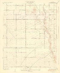
1930 Map of Oban
USGS Topo · Published 1930About this map
The Southern Pacific railroad line forms the primary spine of development across this desert landscape, connecting small outposts in the Antelope Valley. A transition from open high-desert terrain to structured civic planning is visible near the southern margin, where the northern edge of Lancaster begins to emerge. This early 1930s survey captures a moment when water was the defining factor for settlement, evidenced by the numerous marked wells dotting the grid. Aviation history is rooted here at the Lancaster Airport, while the remote character of the region is emphasized by lonely stations like Oban Siding and the sprawling Rosamond Dry Lake to the northeast. A network of early thoroughfares, including Rogers Road and Fairmont Road, establishes a surveyor’s grid that would eventually underpin the growth of this northern Los Angeles County corridor.
Find a feature on this map
24 named features on this map. Tap any name to fly to it.
Don’t see what you’re looking for? This feature index may not catch every label — zoom into the map to look around manually.
Map Details
Editions of this 1930 Oban Map
This is the sole edition of this map. No revisions or reprints were ever made.
Other maps of this area

1915 · Elizabeth Lake
USGS Topo · 1:125,000

1917 · Elizabeth Lake
USGS Topo · 1:125,000

1930 · Roosevelt School
USGS Topo · 1:24,000

1930 · Lancaster
USGS Topo · 1:24,000

1930 · Tierra Bonita
USGS Topo · 1:24,000

1931 · Del Sur
USGS Topo · 1:24,000

1931 · Esperanza School
USGS Topo · 1:24,000

1933 · Lancaster
USGS Topo · 1:24,000

1933 · Roosevelt School
USGS Topo · 1:24,000
1933 · Tierra Bonita
USGS Topo · 1:24,000