
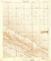
1931 Map of Little Buttes
USGS Topo · Published 1931About this map
The expansive Antelope Valley floor meets the sharp rise of the Antelope Buttes in this 1931 survey of the high desert. Settlement is defined by early ranching footprints, such as the Eric Munz Ranch and Half Circle G Ranch, highlighting the isolation and scale of land ownership in this era. The surveyor's grid of avenues, ranging from Avenue B down to Avenue H, imposes a strict geometry over the terrain, though much of the infrastructure remains dedicated to power and transit. The Southern California Edison Co Transmission Line cuts diagonally across the desert floor, a symbol of the growing regional utility network. Near the Los Angeles Co-Kern Co Boundary Line, the presence of the (Esperanza School) points to a small but established community of homesteaders and ranch hands working the land before the mid-century expansion of the Los Angeles basin.
Find a feature on this map
21 named features on this map. Tap any name to fly to it.
Don’t see what you’re looking for? This feature index may not catch every label — zoom into the map to look around manually.
Map Details
Editions of this 1931 Little Buttes Map
This is the sole edition of this map. No revisions or reprints were ever made.
Other maps of this area

1915 · Elizabeth Lake
USGS Topo · 1:125,000

1917 · Elizabeth Lake
USGS Topo · 1:125,000

1931 · Del Sur
USGS Topo · 1:24,000

1931 · Esperanza School
USGS Topo · 1:24,000

1932 · Lake
USGS Topo · 1:24,000

1932 · Hughes Lake
USGS Topo · 1:24,000

1932 · Fairmont
USGS Topo · 1:24,000

1934 · Little Buttes
USGS Topo · 1:24,000

1934 · Esperanza School
USGS Topo · 1:24,000
1936 · Del Sur
USGS Topo · 1:24,000