1930s Maps of Azusa, California
Explore 4 historic maps of Azusa from the 1930s. These maps offer a rare glimpse into what life looked like during the 1930s — showing old roads, neighborhoods, homes, and landmarks that have changed or disappeared over time.
Whether you're researching your family's past, planning a metal detecting trip, or studying how Azusa's landscape evolved across the 1930s, these high-resolution maps are a powerful tool for exploring the history of this region.
- Focus on a specific era: All maps on this page are from the 1930s, giving you a focused view of this time period.
- See what’s changed: Compare century-old streets, trails, and buildings to today's modern landscape using overlays and satellite layers.
- Research with precision: Use these maps for genealogy, historical research, land use analysis, or educational projects.
- View, download, or print: Maps are fully viewable online in high resolution, and can be downloaded or printed for your own records.
Start exploring Azusa's history through authentic maps from the 1930s. This is your window into the past.
Azusa, CA maps
(4)- 1933 Map of Glendora
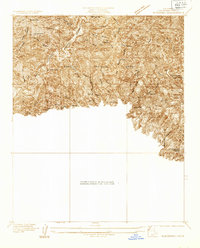 1933 Glendora1933 Print · USGSThe San Gabriel Mountains come into focus during the early 1930s as vital water infrastructure begins to reshape the canyons. Researchers can trace early engineering feats at Morris Dam and Big Dalton Dam or locate the Kelsey Mine.
 - 1933 Map of Azusa
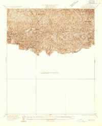 1933 Azusa1933 Print · USGSThe San Gabriel foothills during the early 1930s show a transition from steep wilderness to specialized health and youth camps. You can trace the footprint of the Canyon Tuberculosis Preventorium and the Spring Boy Scout Camp near Bradbury.
 - 1939 Map of Azusa
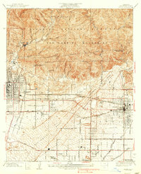 1939 Azusa1939 Print · USGSThe foothills of the San Gabriel Mountains come alive in the late 1930s, showing the transition from citrus groves to early suburban development. Researchers can trace the extensive rail networks of the Pacific Electric Railway and find local landmarks like Liveoak Cemetery and the South Pasadena Veterans Camp.3 unique versions available
 - 1939 Map of Glendora
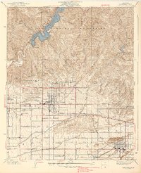 1939 Glendora1939 Print · USGSThe San Gabriel Valley is captured here during a period of transition between its agricultural roots and suburban growth in the late thirties. Researchers can trace historic rail lines like the Pacific Electric and locate vanished institutions including Carlin Military Academy and Charter Oak.3 unique versions available
End of results
Showing maps 1-4 of 4
Top cities near Azusa
- Pomona historical maps
- Pasadena historical maps
- Fullerton historical maps
- Downey historical maps
- El Monte historical maps
- West Covina historical maps
See more
Frequently asked questions
- What are the different types of historical maps available for Azusa?
- What is the oldest map of Azusa?
- Where can I purchase historical maps of Azusa for my home or office?
- Where can I download high-res historical maps of Azusa?
- Are there historical topographic maps available for Azusa?
- Is there historical aerial imagery available for Azusa?
- Where are historical maps of Azusa sourced from?