1930s Maps of Castaic, California
Explore 2 historic maps of Castaic from the 1930s. These maps offer a rare glimpse into what life looked like during the 1930s — showing old roads, neighborhoods, homes, and landmarks that have changed or disappeared over time.
Whether you're researching your family's past, planning a metal detecting trip, or studying how Castaic's landscape evolved across the 1930s, these high-resolution maps are a powerful tool for exploring the history of this region.
- Focus on a specific era: All maps on this page are from the 1930s, giving you a focused view of this time period.
- See what’s changed: Compare century-old streets, trails, and buildings to today's modern landscape using overlays and satellite layers.
- Research with precision: Use these maps for genealogy, historical research, land use analysis, or educational projects.
- View, download, or print: Maps are fully viewable online in high resolution, and can be downloaded or printed for your own records.
Start exploring Castaic's history through authentic maps from the 1930s. This is your window into the past.
Castaic, CA maps
(2)- 1931 Map of Castaic
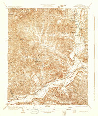 1931 Castaic1931 Print · USGSCastaic and the Santa Clara River valley appear here in the early 1930s, caught between the era of ranching and the rise of the oil industry. Researchers can find family landmarks like Sloane Ranch and the Val Verde Lodge, or trace the old U S Highway No 99.
 - 1937 Map of Violin Canyon
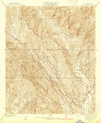 1937 Violin Canyon1937 Print · USGSThe northern Los Angeles County mountains in the late 1930s are captured here as a landscape of isolated ranches and early highways. Researchers can locate early family holdings like Cordova Ranch, follow the original path of Route 99, and spot the Airway Beacon used by early aviators.4 unique versions available
End of results
Showing maps 1-2 of 2
Top cities near Castaic
- Los Angeles historical maps
- Santa Clarita historical maps
- Simi Valley historical maps
- Moorpark historical maps
- San Fernando historical maps
- Val Verde historical maps
Top neighborhoods of Castaic
Frequently asked questions
- What are the different types of historical maps available for Castaic?
- What is the oldest map of Castaic?
- Where can I purchase historical maps of Castaic for my home or office?
- Where can I download high-res historical maps of Castaic?
- Are there historical topographic maps available for Castaic?
- Is there historical aerial imagery available for Castaic?
- Where are historical maps of Castaic sourced from?