1900s (20th Century) Maps of Castaic, California
Explore 25 historic maps of Castaic from the 1900s (20th Century). These maps offer a rare glimpse into what life looked like during the 1900s — showing old roads, neighborhoods, homes, and landmarks that have changed or disappeared over time.
Whether you're researching your family's past, planning a metal detecting trip, or studying how Castaic's landscape evolved across the 1900s, these high-resolution maps are a powerful tool for exploring the history of this region.
- Focus on a specific era: All maps on this page are from the 1900s, giving you a focused view of this time period.
- See what’s changed: Compare century-old streets, trails, and buildings to today's modern landscape using overlays and satellite layers.
- Research with precision: Use these maps for genealogy, historical research, land use analysis, or educational projects.
- View, download, or print: Maps are fully viewable online in high resolution, and can be downloaded or printed for your own records.
Start exploring Castaic's history through authentic maps from the 1900s. This is your window into the past.
Castaic, CA maps
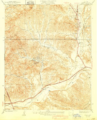
(25)- 1903 Map of Tejon
 1903 Tejon1903 Print · USGSThe high passes and desert fringes of the Tehachapis come alive in this survey of the early twentieth-century frontier. Genealogists and historians can trace the foundations of Old Fort Tejon, follow the trail through Tejon Pass, or locate early mining sites like Frazier Mine.7 unique versions available
 - 1903 Map of Camulos
 1903 Camulos1903 Print · USGSSouthern California at the dawn of the twentieth century shows a landscape of ranchos and early rail towns. Trace the old routes through Simi and Camulos, or locate vanished stops like Ternez Siding and the coastal piers at Port Los Angeles.5 unique versions available
 - 1903 Map of Santa Susana
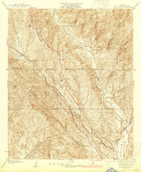
 1903 Santa Susana1903 Print · USGSNorthern Los Angeles and Ventura counties are captured here at the start of the twentieth century, as the railroad transformed the frontier. Trace early rail hubs at Newhall and Saugus, and find the engineering feats of the Santa Susana Tunnel and Fernando Tunnel.8 unique versions available
 - 1931 Map of Castaic
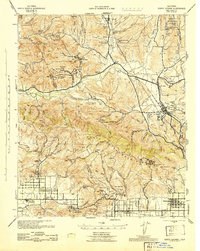
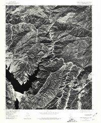
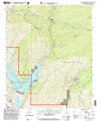
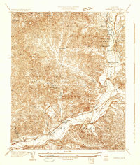 1931 Castaic1931 Print · USGSCastaic and the Santa Clara River valley appear here in the early 1930s, caught between the era of ranching and the rise of the oil industry. Researchers can find family landmarks like Sloane Ranch and the Val Verde Lodge, or trace the old U S Highway No 99.
 - 1937 Map of Violin Canyon
 1937 Violin Canyon1937 Print · USGSThe northern Los Angeles County mountains in the late 1930s are captured here as a landscape of isolated ranches and early highways. Researchers can locate early family holdings like Cordova Ranch, follow the original path of Route 99, and spot the Airway Beacon used by early aviators.4 unique versions available
 - 1940 Map of Castaic
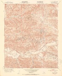
 1940 Castaic1940 Print · USGSNorth of Los Angeles in the 1940s, the canyons around the Santa Clara River supported a network of isolated waystations and small schools. Genealogists can trace family footprints at Liveoak Sch, Valverde Lodge, or the agricultural Wayside Farm No 1.3 unique versions available
 - 1941 Map of Santa Susana, 1964 Print
 1941 Santa Susana1964 Print · USGSVentura and Los Angeles counties meet in this 1940s landscape of steep canyons and early oil development. Researchers can trace the ranching history of Brandeis Ranch and Iverson Ranch or locate industrial sites like the Newhall-Potrero Oil Field.2 unique versions available
 - 1943 Map of Santa Susana
 1943 Santa Susana1943 Print · USGSSouthern California ranching and oil industries intersect in the early 1940s along the Santa Susana Mountains. Trace historic boundaries and sites like Tapo Ranch, the Newhall-Potrero Oil Field, and the Southern Pacific rail line.
 - 1949 Map of Los Angeles
 1949 Los Angeles1949 Print · USGSSouthern California and the South Coast appear at the onset of the post-war boom, from the Channel Islands to the Mojave Desert. Trace early aviation sites like Lockheed Air Terminal and mining history at the Redrock Quicksilver Mine and Redrover Mine.2 unique versions available
 - 1952 Map of Val Verde, 1953 Print
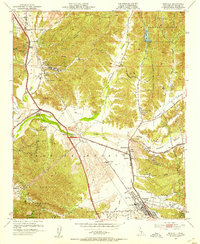
 1952 Val Verde1953 Print · USGSThe Santa Clara River valley and the petroleum-rich canyons of the Santa Susana Mountains are shown here in the early fifties. Researchers can trace historic family holdings like Hathaway Ranch and Lechler Ranch alongside the Southern Pacific line.7 unique versions available
 - 1952 Map of Newhall, 1953 Print
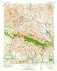
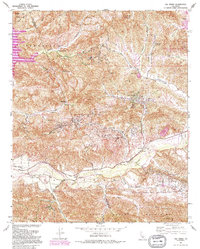
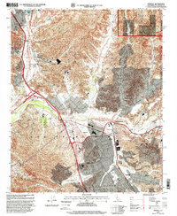
 1952 Newhall1953 Print · USGSThe Santa Clarita Valley was a landscape of citrus, cattle, and crude oil in the early fifties before it became a suburban corridor. Genealogists and historians can trace old family holdings like Bonelli Ranch, find early schools such as Hart School, and locate the Oil Wells that fueled the local economy.6 unique versions available
 - 1955 Map of Los Angeles
 1955 Los Angeles1955 Print · USGSThe mid-century transformation of Southern California comes into focus as the urban sprawl of Los Angeles meets the wilderness of the Santa Monica Mountains. Researchers can trace the development of post-war suburbs alongside historic landmarks like the Santa Barbara Lighthouse and early industrial sites such as the Good Luck Mine.
 - 1958 Map of Warm Springs Mountain, 1959 Print
 1958 Warm Springs Mountain1959 Print · USGSIn the late fifties, this portion of the Angeles National Forest balanced rugged water-power infrastructure with seasonal recreation. Researchers can trace the path of the Los Angeles Aqueduct Tunnel or locate historic sites like Warm Springs Camp and Daries Ranch.4 unique versions available
 - 1958 Map of Whitaker Peak, 1959 Print
 1958 Whitaker Peak1959 Print · USGSThe mountain passes of northern Los Angeles County are captured here in the late fifties during the era of the Golden State Highway (Five Mile Grade). Researchers can trace old mountain routes and forest outposts like Paradise Ranch, Frenchmans Flat Campground, and the Whitaker Peak Lookout.5 unique versions available
 - 1959 Map of Los Angeles
 1959 Los Angeles1959 Print · USGSCoastal California and the high desert met in a period of booming growth after the war. Researchers can trace early aviation and military history at the Point Mugu Air Missile Test Ctr or locate desert mining sites like the Double Eagle Mine.3 unique versions available
 - 1966 Map of Los Angeles
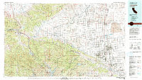
 1966 Los Angeles1966 Print · USGSSouthern California underwent a mid-century transformation as suburban grids reached the base of the San Gabriel Mountains. Researchers can trace the path of the Los Angeles Aqueduct or locate defense landmarks like Edwards Air Force Base.
 - 1975 Map of Los Angeles, 1977 Print
 1975 Los Angeles1977 Print · USGSSouthern California is captured in a period of significant growth during the mid-seventies, showing the urban sprawl from the coast to the high desert. Researchers can trace the development of the Pacific Coast Hwy and find aerospace landmarks like Edwards Air Force Base and the Flight Test Center (NASA).2 unique versions available
 - 1978 Map of Warm Springs Mtn, 1981 Print
 1978 Warm Springs Mtn1981 Print · USGSNorthern Los Angeles County is captured in detailed aerial imagery during the late seventies, showing the remote high-country terrain before modern shifts. Researchers can trace the layout of Warm Springs Camp and the winding route through Francisquito Canyon.
 - 1979 Map of Los Angeles
 1979 Los Angeles1979 Print · USGSSouthern California at the close of the 1970s reveals a sprawling network of suburban growth and massive infrastructure projects. Researchers can trace established rail lines like the Southern Pacific alongside newer settlements and landmarks like Virginia Colony and Griffith Park.
 - 1981 Map of Lancaster, 1984 Print
 1981 Lancaster1984 Print · USGSThe high desert and mountain passes of northern Los Angeles County come alive in this early eighties survey. Researchers can trace the San Andreas Rift Zone past remote outposts like Gorman or locate the historic Golden Queen Mine near the Mojave edge.2 unique versions available
 - 1991 Map of Val Verde, 1995 Print
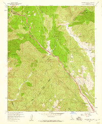
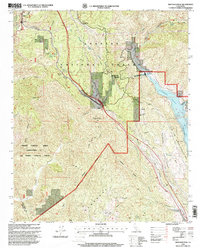
 1991 Val Verde1995 Print · USGSThe northern Santa Susana Mountains meet the Santa Clara River in the 1990s, revealing an era of intense oil extraction and ranching. Genealogists and historians can trace family holdings like Lechler Ranch alongside industrial landmarks like Mayo Spur and the Ramona Oil Field.
 - 1995 Map of Val Verde, 1999 Print
 1995 Val Verde1999 Print · USGSNorth of Los Angeles in the mid-nineties, the Santa Clara River valley remained a landscape of active oil fields and sprawling ranches. Genealogists and local historians can trace the foundations of Val Verde, locate the Cem near Hasley, and explore the legacy of Stanley Ranch.
 - 1995 Map of Warm Springs Mountain, 1999 Print
 1995 Warm Springs Mountain1999 Print · USGSThe Angeles National Forest in the mid-1990s reveals a landscape of high ridgelines and essential water infrastructure north of Los Angeles. Historians and researchers can trace the development of Castaic Lake and locate specific sites like Powerhouse No 2 and Warm Springs Camp.
 - 1995 Map of Newhall, 1999 Print
 1995 Newhall1999 Print · USGSSanta Clarita and the Santa Clara River valley are shown in a period of significant growth during the mid-nineties. Local historians can trace the evolution of Saugus and Newhall or locate landmarks like the Newhall Oil Field and Saugus School.
 - 1995 Map of Whitaker Peak, 1999 Print
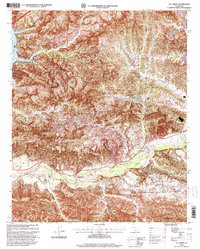
 1995 Whitaker Peak1999 Print · USGSThe Los Angeles mountains come alive in the mid-nineties as the historic Old Ridge Route meets modern water infrastructure. Researchers can trace the legacy of mountain travel and energy at Paradise Ranch, the Beacon Forest Inn, and the Castaic Powerplant.
End of results
Showing maps 1-25 of 25
Top cities near Castaic
- Los Angeles historical maps
- Santa Clarita historical maps
- Simi Valley historical maps
- Moorpark historical maps
- San Fernando historical maps
- Val Verde historical maps
Top neighborhoods of Castaic
Frequently asked questions
- What are the different types of historical maps available for Castaic?
- What is the oldest map of Castaic?
- Where can I purchase historical maps of Castaic for my home or office?
- Where can I download high-res historical maps of Castaic?
- Are there historical topographic maps available for Castaic?
- Is there historical aerial imagery available for Castaic?
- Where are historical maps of Castaic sourced from?