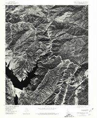
1978 Map of Warm Springs Mtn
USGS Topo · Published 1981About this map
Warm Springs Camp sits within a complex network of ridgelines and deep drainages in the Angeles National Forest during the late 1970s. This orthophotoquad, produced by the Geological Survey in cooperation with the Forest Service, uses aerial imagery to reveal the stark contrast between the steep, shadowed slopes of Warm Springs Mtn. and the winding corridor of Francisquito Canyon. The visual data provides a clear record of the watershed and vegetation patterns surrounding Red Mountain, documenting the land surface before subsequent developments or natural changes altered the terrain. By using rectified photoimagery, the map captures the precise footprint of the camp and the local road system as it navigated the difficult topography of northern Los Angeles County.
Find a feature on this map
4 named features on this map. Tap any name to fly to it.
Don’t see what you’re looking for? This feature index may not catch every label — zoom into the map to look around manually.
Map Details
Editions of this 1978 Warm Springs Mtn Map
This is the sole edition of this map. No revisions or reprints were ever made.
Other maps of this area

1900 · Fernando
USGS Topo · 1:62,500

1901 · Southern California Sheet No. 1
USGS Topo · 1:250,000

1903 · Tejon
USGS Topo · 1:125,000

1903 · Camulos
USGS Topo · 1:125,000

1903 · Santa Susana
USGS Topo · 1:62,500

1904 · Southern California Sheet No. 1
USGS Topo · 1:250,000

1915 · Elizabeth Lake
USGS Topo · 1:125,000

1917 · Elizabeth Lake
USGS Topo · 1:125,000

1929 · Saugus
USGS Topo · 1:24,000

1931 · Red Mountain
USGS Topo · 1:24,000