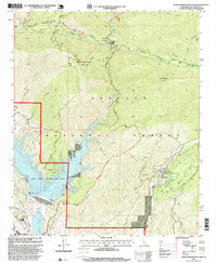
1995 Map of Warm Springs Mountain
USGS Topo · Published 1999About this map
Warm Springs Mountain and the deep drainage of Elizabeth Lake Canyon define this rugged portion of the Angeles National Forest in the mid-1990s. The landscape is characterized by its complex hydroelectric and water management infrastructure, including the Castaic Lake reservoir and the Castaic Lagoon south of the dam. To the east, the map details the historic corridor along San Francisquito Canyon Road, where the San Francisquito Canyon Station, Powerhouse No 2, and Drinkwater Reservoir indicate the ongoing importance of water transit and power generation for the region. Significant elevation changes are marked by named peaks like Red Mountain and the remote Warm Springs Camp, while various canyons such as Charlie Canyon and Fish Canyon create a dense network of seasonal drainages across the forest terrain.
Find a feature on this map
54 named features on this map. Tap any name to fly to it.
Don’t see what you’re looking for? This feature index may not catch every label — zoom into the map to look around manually.
Map Details
Editions of this 1995 Warm Springs Mountain Map
This is the sole edition of this map. No revisions or reprints were ever made.
Other maps of this area

1900 · Fernando
USGS Topo · 1:62,500

1901 · Southern California Sheet No. 1
USGS Topo · 1:250,000

1903 · Tejon
USGS Topo · 1:125,000

1903 · Camulos
USGS Topo · 1:125,000

1903 · Santa Susana
USGS Topo · 1:62,500

1904 · Southern California Sheet No. 1
USGS Topo · 1:250,000

1915 · Elizabeth Lake
USGS Topo · 1:125,000

1917 · Elizabeth Lake
USGS Topo · 1:125,000

1929 · Saugus
USGS Topo · 1:24,000

1931 · Red Mountain
USGS Topo · 1:24,000