1930s Maps of Caswell, California
Explore 2 historic maps of Caswell from the 1930s. These maps offer a rare glimpse into what life looked like during the 1930s — showing old roads, neighborhoods, homes, and landmarks that have changed or disappeared over time.
Whether you're researching your family's past, planning a metal detecting trip, or studying how Caswell's landscape evolved across the 1930s, these high-resolution maps are a powerful tool for exploring the history of this region.
- Focus on a specific era: All maps on this page are from the 1930s, giving you a focused view of this time period.
- See what’s changed: Compare century-old streets, trails, and buildings to today's modern landscape using overlays and satellite layers.
- Research with precision: Use these maps for genealogy, historical research, land use analysis, or educational projects.
- View, download, or print: Maps are fully viewable online in high resolution, and can be downloaded or printed for your own records.
Start exploring Caswell's history through authentic maps from the 1930s. This is your window into the past.
Caswell, CA maps
(2)- 1933 Map of Quail
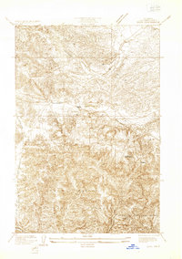 1933 Quail1933 Print · USGSThe Tejon Pass region during the early thirties shows a critical moment in California's highway history as travel shifted through the mountains. Researchers can trace the original Ridge Route, locate the Quail Lake School, and find early roadside stops like Sandberg and Tumble Inn.
 - 1938 Map of Quail
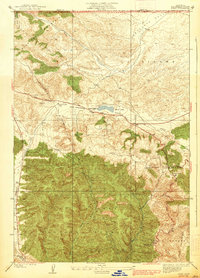 1938 Quail1938 Print · USGSUpper Los Angeles County in the late thirties is defined by the high-mountain passage between the Central Valley and the coast. Trace the winding Old Ridge Route to find historic waypoints like Sandberg, the Tumble Inn, and the Quail Lake Sch.5 unique versions available
End of results
Showing maps 1-2 of 2
Frequently asked questions
- What are the different types of historical maps available for Caswell?
- What is the oldest map of Caswell?
- Where can I purchase historical maps of Caswell for my home or office?
- Where can I download high-res historical maps of Caswell?
- Are there historical topographic maps available for Caswell?
- Is there historical aerial imagery available for Caswell?
- Where are historical maps of Caswell sourced from?