Old Maps of Caswell, California
Explore 18 old maps of Caswell, spanning from 1903 to today. These high-resolution historic maps reveal how streets, neighborhoods, landmarks, and natural features evolved over time — perfect for genealogy, metal detecting, research, and local history exploration.
What you can do with these maps:
- See how Caswell changed over time: Compare historical maps to modern-day views to trace roads, homesites, rail lines & more.
- View detailed metadata: Each map includes creators, publishers, year, scale, and archive source.
- Overlay maps with satellite & LiDAR: Visualize the past alongside modern tools to explore terrain & human change.
- Trusted historical sources: Maps sourced from the USGS, Library of Congress, and other archives.
- Access maps your way: View online, download high-res files, or order prints for personal or research use.
Start exploring old maps of Caswell to uncover forgotten places, hidden landmarks, and the deep history beneath your feet.
Caswell, CA maps
(18)- 1903 Map of Tejon
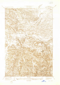
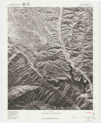
 1903 Tejon1903 Print · USGSThe high passes and desert fringes of the Tehachapis come alive in this survey of the early twentieth-century frontier. Genealogists and historians can trace the foundations of Old Fort Tejon, follow the trail through Tejon Pass, or locate early mining sites like Frazier Mine.7 unique versions available
 - 1933 Map of Quail
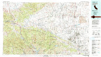
 1933 Quail1933 Print · USGSThe Tejon Pass region during the early thirties shows a critical moment in California's highway history as travel shifted through the mountains. Researchers can trace the original Ridge Route, locate the Quail Lake School, and find early roadside stops like Sandberg and Tumble Inn.
 - 1938 Map of Quail
 1938 Quail1938 Print · USGSUpper Los Angeles County in the late thirties is defined by the high-mountain passage between the Central Valley and the coast. Trace the winding Old Ridge Route to find historic waypoints like Sandberg, the Tumble Inn, and the Quail Lake Sch.5 unique versions available
 - 1945 Map of Black Mtn
 1945 Black Mtn1945 Print · USGSThe high canyons of the Los Angeles and Ventura border were a critical utility corridor during the mid-1940s. Local historians can trace the foundations of Lane Ranch, locate the Bayley Homestead, and find old service outposts like Delos.
 - 1949 Map of Los Angeles
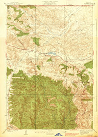
 1949 Los Angeles1949 Print · USGSSouthern California and the South Coast appear at the onset of the post-war boom, from the Channel Islands to the Mojave Desert. Trace early aviation sites like Lockheed Air Terminal and mining history at the Redrock Quicksilver Mine and Redrover Mine.2 unique versions available
 - 1955 Map of Los Angeles
 1955 Los Angeles1955 Print · USGSThe mid-century transformation of Southern California comes into focus as the urban sprawl of Los Angeles meets the wilderness of the Santa Monica Mountains. Researchers can trace the development of post-war suburbs alongside historic landmarks like the Santa Barbara Lighthouse and early industrial sites such as the Good Luck Mine.
 - 1958 Map of Black Mtn, 1959 Print
 1958 Black Mtn1959 Print · USGSNorthern Los Angeles County is captured here in the late fifties, showcasing the transition from ranching life to modernized transportation. Genealogists and historians can trace family sites like the Bailey Homestead and Lane Ranch alongside the Golden State Highway.5 unique versions available
 - 1959 Map of Los Angeles
 1959 Los Angeles1959 Print · USGSCoastal California and the high desert met in a period of booming growth after the war. Researchers can trace early aviation and military history at the Point Mugu Air Missile Test Ctr or locate desert mining sites like the Double Eagle Mine.3 unique versions available
 - 1966 Map of Los Angeles
 1966 Los Angeles1966 Print · USGSSouthern California underwent a mid-century transformation as suburban grids reached the base of the San Gabriel Mountains. Researchers can trace the path of the Los Angeles Aqueduct or locate defense landmarks like Edwards Air Force Base.
 - 1975 Map of Los Angeles, 1977 Print
 1975 Los Angeles1977 Print · USGSSouthern California is captured in a period of significant growth during the mid-seventies, showing the urban sprawl from the coast to the high desert. Researchers can trace the development of the Pacific Coast Hwy and find aerospace landmarks like Edwards Air Force Base and the Flight Test Center (NASA).2 unique versions available
 - 1978 Map of Black Mtn
 1978 Black Mtn1978 Print · USGSCovers Caswell, including Ventura County, Los Angeles County, and other nearby areas
 - 1981 Map of Lancaster, 1984 Print
 1981 Lancaster1984 Print · USGSThe high desert and mountain passes of northern Los Angeles County come alive in this early eighties survey. Researchers can trace the San Andreas Rift Zone past remote outposts like Gorman or locate the historic Golden Queen Mine near the Mojave edge.2 unique versions available
 - 1991 Map of Black Mountain, 1992 Print
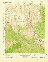
 1991 Black Mountain1992 Print · USGSSouthern California's rugged backcountry at the junction of Ventura and Los Angeles counties is shown here during the early nineties. Genealogists and local historians can locate the former Kinsey Ranch and Bailey Homestead near the shores of Pyramid Lake.2 unique versions available
 - 1995 Map of Black Mountain, 2000 Print
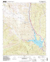
 1995 Black Mountain2000 Print · USGSLos Angeles County in the mid-1990s shows a landscape of massive water infrastructure and backcountry recreation at the forest edge. Researchers can trace the original Bailey Homestead (Site) and the Caswell (Site) near the waters of Pyramid Lake.
 - 2012 Map of Black Mountain, 2012 Print
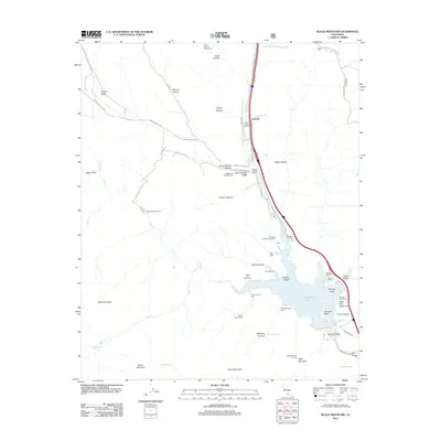 2012 Black Mountain2012 Print · USGSCovers Caswell, including Ventura County, Los Angeles County, and other nearby areas
 - 2015 Map of Black Mountain, 2015 Print
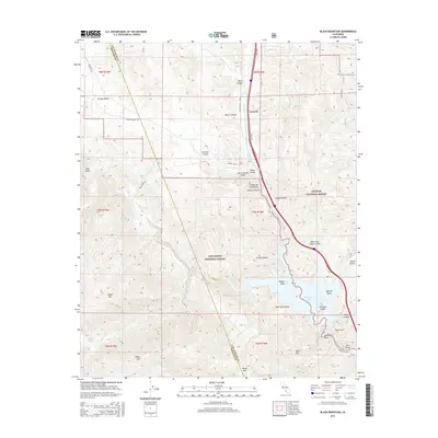 2015 Black Mountain2015 Print · USGSCovers Caswell, including Ventura County, Los Angeles County, and other nearby areas
 - 2018 Map of Black Mountain, 2018 Print
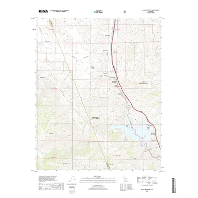 2018 Black Mountain2018 Print · USGSCovers Caswell, including Ventura County, Los Angeles County, and other nearby areas
 - 2022 Map of Black Mountain, 2022 Print
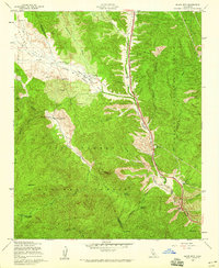
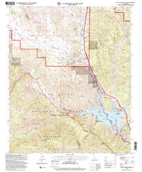
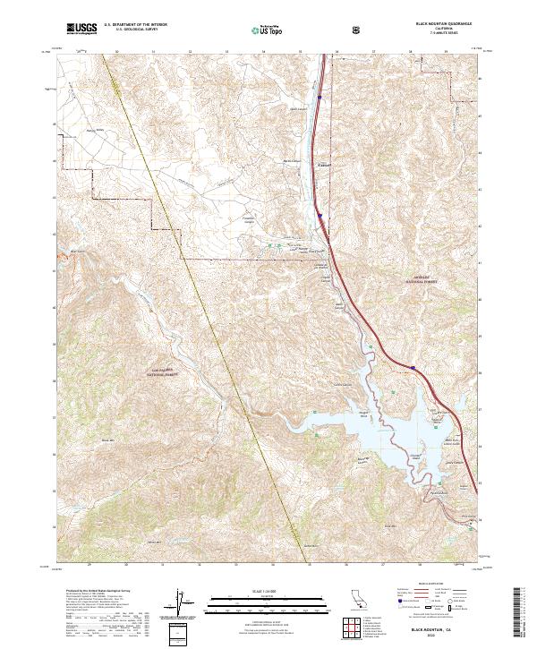 2022 Black Mountain2022 Print · USGSThe rugged divide of the Tehachapi Mountains and the Los Angeles County line comes into focus in this recent survey. Researchers can trace the engineering of Pyramid Lake, the path of the Angeles Tunnel, and landmarks like Chumash Island.
End of results
Showing maps 1-18 of 18
Frequently asked questions
- What are the different types of historical maps available for Caswell?
- What is the oldest map of Caswell?
- Where can I purchase historical maps of Caswell for my home or office?
- Where can I download high-res historical maps of Caswell?
- Are there historical topographic maps available for Caswell?
- Is there historical aerial imagery available for Caswell?
- Where are historical maps of Caswell sourced from?