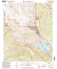
1995 Map of Black Mountain
USGS Topo · Published 2000About this map
Pyramid Lake and the rugged northern reaches of the Angeles National Forest dominate this mid-1990s survey, marking a landscape where water management meets large-scale public recreation. The map captures the infrastructure of the California Aqueduct, including the William E Warne Power Plant and Pyramid Dam, while also documenting the Hungry Valley State Vehicular Recreation Area and its headquarters. For local historians, the sheet preserves several significant cultural markers, such as the Bailey Homestead (Site) and Caswell (Site), alongside more modern developments like the Vista del Lago Visitor Center. The terrain is deeply carved by drainage systems including Gorman Creek and Piru Creek, while trails like the Piru Creek Trail and Beartrap Trail offer access to the primitive Sespe Wilderness in the south.
Find a feature on this map
78 named features on this map. Tap any name to fly to it.
Don’t see what you’re looking for? This feature index may not catch every label — zoom into the map to look around manually.
Map Details
Editions of this 1995 Black Mountain Map
This is the sole edition of this map. No revisions or reprints were ever made.
Other maps of this area

1903 · Tejon
USGS Topo · 1:125,000

1932 · Beartrap Canyon
USGS Topo · 1:24,000

1933 · Quail
USGS Topo · 1:24,000

1933 · Gorman
USGS Topo · 1:24,000

1938 · Beartrap Canyon
USGS Topo · 1:24,000

1938 · Gorman
USGS Topo · 1:24,000

1938 · Black Mountain
USGS Topo · 1:24,000

1938 · Quail
USGS Topo · 1:24,000

1942 · Frazier Mountain
USGS Topo · 1:24,000

1943 · Neenach
USGS Topo · 1:62,500