1940s Maps of Chilao, California
Explore 4 historic maps of Chilao from the 1940s. These maps offer a rare glimpse into what life looked like during the 1940s — showing old roads, neighborhoods, homes, and landmarks that have changed or disappeared over time.
Whether you're researching your family's past, planning a metal detecting trip, or studying how Chilao's landscape evolved across the 1940s, these high-resolution maps are a powerful tool for exploring the history of this region.
- Focus on a specific era: All maps on this page are from the 1940s, giving you a focused view of this time period.
- See what’s changed: Compare century-old streets, trails, and buildings to today's modern landscape using overlays and satellite layers.
- Research with precision: Use these maps for genealogy, historical research, land use analysis, or educational projects.
- View, download, or print: Maps are fully viewable online in high resolution, and can be downloaded or printed for your own records.
Start exploring Chilao's history through authentic maps from the 1940s. This is your window into the past.
Chilao, CA maps
(4)- 1940 Map of Acton, 1955 Print
 1940 Acton1955 Print · USGSThe high canyons of the San Gabriel Mountains are captured here during the 1940s, showing the early reach of water infrastructure and mining in the region. Genealogists and historians can trace the Southern Pacific rail line through Acton and Ravenna, or locate remote sites like the Monte Cristo Mine.
 - 1941 Map of Alder Creek
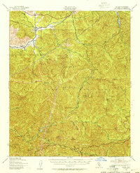
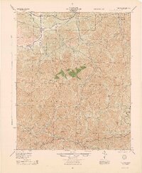
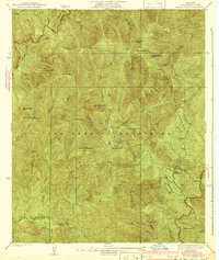 1941 Alder Creek1941 Print · USGSDeep in the San Gabriel Mountains during the mid-1930s, this survey reveals a landscape of high summits and early forest infrastructure. Researchers can locate the Monte Cristo Mine, Loomis Ranch, and the Chilao Guard Station as they appeared before the war.3 unique versions available
 - 1944 Map of Tujunga
 1944 Tujunga1944 Print · USGSThe high canyons and desert fringes of the San Gabriel Mountains are captured here during the mid-forties. Genealogists and historians can trace the Southern Pacific rail line through Acton or locate the historic Monte Cristo Mines and the Tujunga Dam.
 - 1949 Map of Los Angeles
 1949 Los Angeles1949 Print · USGSSouthern California and the South Coast appear at the onset of the post-war boom, from the Channel Islands to the Mojave Desert. Trace early aviation sites like Lockheed Air Terminal and mining history at the Redrock Quicksilver Mine and Redrover Mine.2 unique versions available
End of results
Showing maps 1-4 of 4
Top cities near Chilao
- Los Angeles historical maps
- Glendale historical maps
- Pomona historical maps
- Palmdale historical maps
- Pasadena historical maps
- Alhambra historical maps
See more
Frequently asked questions
- What are the different types of historical maps available for Chilao?
- What is the oldest map of Chilao?
- Where can I purchase historical maps of Chilao for my home or office?
- Where can I download high-res historical maps of Chilao?
- Are there historical topographic maps available for Chilao?
- Is there historical aerial imagery available for Chilao?
- Where are historical maps of Chilao sourced from?