1920s Maps of City of Industry, California
Explore 6 historic maps of City of Industry from the 1920s. These maps offer a rare glimpse into what life looked like during the 1920s — showing old roads, neighborhoods, homes, and landmarks that have changed or disappeared over time.
Whether you're researching your family's past, planning a metal detecting trip, or studying how City of Industry's landscape evolved across the 1920s, these high-resolution maps are a powerful tool for exploring the history of this region.
- Focus on a specific era: All maps on this page are from the 1920s, giving you a focused view of this time period.
- See what’s changed: Compare century-old streets, trails, and buildings to today's modern landscape using overlays and satellite layers.
- Research with precision: Use these maps for genealogy, historical research, land use analysis, or educational projects.
- View, download, or print: Maps are fully viewable online in high resolution, and can be downloaded or printed for your own records.
Start exploring City of Industry's history through authentic maps from the 1920s. This is your window into the past.
City of Industry, CA maps
(6)- 1923 Map of El Monte
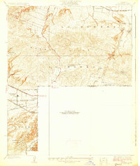
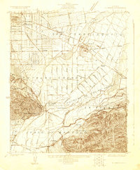 1923 El Monte1923 Print · USGSThe San Gabriel Valley was a thriving agricultural and rail corridor in the years following the Great War. You can trace early township boundaries and find the sites of rural schools and industry, from the O'Donnel Oil Refinery to the Temple School.
 - 1926 Map of El Monte
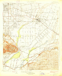 1926 El Monte1926 Print · USGSThe San Gabriel Valley in the mid-twenties shows a landscape of historic ranchos transitioning into suburban clusters along the rail lines. Genealogists and researchers can trace early homesteads and schools like Temple School or the industrial footprint of the O'Donnel Oil Refinery.2 unique versions available
 - 1927 Map of Covina
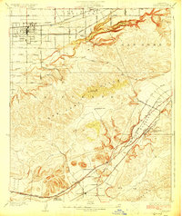 1927 Covina1927 Print · USGSThe eastern San Gabriel Valley was a thriving agricultural and transit hub in the 1920s, dominated by orchards and sprawling ranch lands. Genealogists can trace family roots through settlements like Covina, the Diamond Bar Ranch, and the Protestant Home for Boys.3 unique versions available
 - 1927 Map of Puente
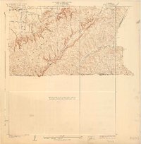
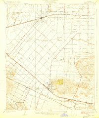 1927 Puente1927 Print · USGSThe San Gabriel Valley is shown in the late twenties during its era of agricultural prominence and early rail expansion. Genealogists can trace family tracts and rural community centers like Fellowship Farm, Temple Ranch, and the West Covina School.2 unique versions available
 - 1927 Map of La Habra
 1927 La Habra1927 Print · USGSSouthern California ranching meets the oil boom in the late twenties as the petroleum industry reshapes the landscape. Genealogists can locate family holdings like Grazide Ranch or trace local education at Lowell Joint School and Rowland School.2 unique versions available
 - 1928 Map of La Brea
 1928 La Brea1928 Print · USGSThe hills of Eastern Los Angeles County are captured here in the late twenties during a period of expanding ranching and early oil exploration. Genealogists and historians can trace family-named sites like Silver Peak Ranch, local landmarks such as Fairview School, and the path of the Union Pacific Railroad.3 unique versions available
End of results
Showing maps 1-6 of 6
Top cities near City of Industry
- Los Angeles historical maps
- Long Beach historical maps
- Anaheim historical maps
- Garden Grove historical maps
- Pomona historical maps
- Pasadena historical maps
See more
Top neighborhoods of City of Industry
Frequently asked questions
- What are the different types of historical maps available for City of Industry?
- What is the oldest map of City of Industry?
- Where can I purchase historical maps of City of Industry for my home or office?
- Where can I download high-res historical maps of City of Industry?
- Are there historical topographic maps available for City of Industry?
- Is there historical aerial imagery available for City of Industry?
- Where are historical maps of City of Industry sourced from?