1920s Maps of South Park, Los Angeles
Explore 2 historic maps of South Park from the 1920s. These maps offer a rare glimpse into what life looked like during the 1920s — showing old roads, neighborhoods, homes, and landmarks that have changed or disappeared over time.
Whether you're researching your family's past, planning a metal detecting trip, or studying how South Park's landscape evolved across the 1920s, these high-resolution maps are a powerful tool for exploring the history of this region.
- Focus on a specific era: All maps on this page are from the 1920s, giving you a focused view of this time period.
- See what’s changed: Compare century-old streets, trails, and buildings to today's modern landscape using overlays and satellite layers.
- Research with precision: Use these maps for genealogy, historical research, land use analysis, or educational projects.
- View, download, or print: Maps are fully viewable online in high resolution, and can be downloaded or printed for your own records.
Start exploring South Park's history through authentic maps from the 1920s. This is your window into the past.
South Park, Los Angeles maps
(2)- 1923 Map of Watts
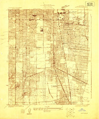 1923 Watts1923 Print · USGSSouth-central Los Angeles is seen here during its mid-twenties transition into a major metropolitan corridor. Researchers can trace early street grids and rail lines through the City of Watts, Lynwood, and schools like Willowbrook School.
 - 1924 Map of Watts
 1924 Watts1924 Print · USGSSouth Los Angeles and its neighboring industrial suburbs come to life in the mid-1920s as a burgeoning network of rail lines and residential grids. Researchers can trace early school sites like Willowbrook School and large-scale industrial landmarks including the Goodyear Rubber Co.2 unique versions available
End of results
Showing maps 1-2 of 2
Frequently asked questions
- What are the different types of historical maps available for South Park?
- What is the oldest map of South Park?
- Where can I purchase historical maps of South Park for my home or office?
- Where can I download high-res historical maps of South Park?
- Are there historical topographic maps available for South Park?
- Is there historical aerial imagery available for South Park?
- Where are historical maps of South Park sourced from?