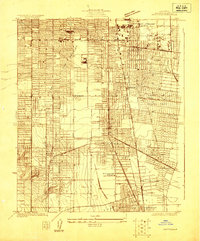
1923 Map of Watts
USGS Topo · Published 1923About this map
The City of Watts stands as a central transit hub in this 1923 survey, caught at a moment of rapid residential expansion and industrial development in southern Los Angeles. The landscape is defined by the extensive reach of the Pacific Electric and Southern Pacific rail lines, which fostered the growth of surrounding municipalities like the City of Huntington Park and the City of South Gate. These rail networks were the lifeblood of the region, connecting the dense street grids of South Park and Florence to the budding industrial centers characterized by Oil Tanks near the City of Vernon. Local life is further anchored by community landmarks such as Willowbrook School and Belle Vernon School, while Leake Lake provides a rare natural focal point amidst the emerging urban fabric of the early twentieth century.
Find a feature on this map
25 named features on this map. Tap any name to fly to it.
Don’t see what you’re looking for? This feature index may not catch every label — zoom into the map to look around manually.
Map Details
Editions of this 1923 Watts Map
This is the sole edition of this map. No revisions or reprints were ever made.
Other maps of this area

1894 · Los Angeles
USGS Topo · 1:62,500

1896 · Pasadena
USGS Topo · 1:62,500

1896 · Redondo
USGS Topo · 1:62,500

1896 · Santa Monica
USGS Topo · 1:62,500

1896 · Downey
USGS Topo · 1:62,500

1898 · Santa Monica
USGS Topo · 1:62,500

1899 · Downey
USGS Topo · 1:62,500

1900 · Pasadena
USGS Topo · 1:62,500

1900 · Los Angeles
USGS Topo · 1:62,500

1901 · Southern California Sheet No. 1
USGS Topo · 1:250,000