Old Maps of Hildreth, California for Academic Research
Study the evolution of Hildreth with 16 high-resolution historic maps. Whether you're teaching, researching, or modeling changes in land use, these maps provide essential visual documentation of urban, environmental, and geographic change.
- Analyze long-term change: Track patterns in development, transportation, and natural features.
- Ideal for environmental or urban studies: Support academic projects with primary historical map data.
- Use in the classroom or lab: Educators and researchers rely on these maps to bring historical context to life.
These maps are a powerful tool for teaching, research, and visualizing how Hildreth has changed over the decades.
Hildreth, CA maps
(16)- 1912 Map of Mariposa
 1912 Mariposa1912 Print · USGSThe California Sierra foothills in the early twentieth century are mapped here as a hive of mining and timber activity. Researchers can trace the legacy of remote settlements and family lands including Grub Gulch, the Indian Settlement, and Knowles.6 unique versions available
 - 1916 Map of Sulphur Springs, 1959 Print
 1916 Sulphur Springs1959 Print · USGSThe canyon lands of the Sierra foothills appear here as they were before the creation of Millerton Lake. Researchers can trace the original riverbanks and historic sites like Old Millerton, Old Fort Miller, and Belleview.2 unique versions available
 - 1919 Map of Sulphur Springs
 1919 Sulphur Springs1919 Print · USGSThe San Joaquin River foothills appear at a crossroads during the late teens, just as the regional landscape began to modernize. Researchers can locate the early sites of Old Fort Miller and Old Millerton or trace the winding Friant and O'neals Road.2 unique versions available
 - 1942 Map of Millerton Lake, 1959 Print
 1942 Millerton Lake1959 Print · USGSThe foothills of Madera and Fresno counties come alive in the 1940s as the San Joaquin River is transformed by the Friant Dam. Genealogists and historians can locate family homesteads like Rosedale Ranch and early rural institutions including Spring Valley Sch and Picayune Rancheria.2 unique versions available
 - 1945 Map of Millerton Lake
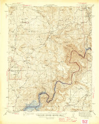 1945 Millerton Lake1945 Print · USGSThe Madera and Fresno County foothills come alive in the 1940s, showing the early years of Millerton Lake and the San Joaquin River gorge. Genealogists and historians can locate remote family sites like Venter and Hildreth, alongside the Picayune Rancheria and Walker Cemetery.2 unique versions available
 - 1947 Map of Mariposa, 1948 Print
 1947 Mariposa1948 Print · USGSThe High Sierra and Owens Valley transition is captured here in the late 1940s, just as the region’s hydroelectric and tourism infrastructure was maturing. Genealogists and historians can trace old ranger stations, the Casa Diablo Mine, and rail stops along the Southern Pacific like Benton Station and Zurich.2 unique versions available
 - 1948 Map of Mariposa, 1951 Print
 1948 Mariposa1951 Print · USGSThe High Sierra and Mariposa foothills are shown here in the late 1940s as the post-war tourism and water infrastructure expanded. Genealogists and historians can locate vanished waypoints like Mormon Bar, the Glacier Point Hotel, and the granite quarries of Knowles.
 - 1957 Map of Mariposa, 1966 Print
 1957 Mariposa1966 Print · USGSThe High Sierra and Owens Valley appear in the mid-fifties, showing the intersection of conservation, hydroelectric power, and mountain industry. Genealogists and researchers can trace local landmarks like Yosemite Cemetery, the remote Kinsley Station, and the Pine Creek Mine.4 unique versions available
 - 1963 Map of Mariposa
 1963 Mariposa1963 Print · USGSThe High Sierra and Owens Valley meet in the early sixties, showing a landscape defined by gold-rush history and massive post-war water projects. Genealogists and researchers can trace old mining routes near Mariposa, locate the Glacier Point Hotel, and find small settlements like Coarse Gold or Knowles Junction.
 - 1965 Map of Millerton Lake West, 1966 Print
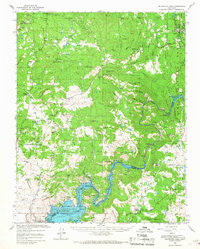
 1965 Millerton Lake West1966 Print · USGSThe Madera and Fresno county line follows the riverbed through the center of this mid-sixties survey as Millerton Lake reaches its full extent. Researchers can trace land use through the San Joaquin Experimental Range and locate the Spring Valley Sch and Bellview (Site).4 unique versions available
 - 1965 Map of Millerton Lake, 1967 Print
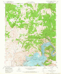
 1965 Millerton Lake1967 Print · USGSThe San Joaquin foothills in the mid-sixties reveal a landscape of family ranches and new reservoirs. Genealogists can trace family landmarks like Veater Ranch and O'Neals, or locate the historic Picayune Cem and Spring Valley Sch.2 unique versions available
 - 1980 Map of Shaver Lake
 1980 Shaver Lake1980 Print · USGSThe Sierra Nevada foothills and high country come into focus during the early eighties, showing the region's complex water and timber infrastructure. Researchers can trace the heritage of local industry at Knowles Quarry, Buchanan Mine, and the hydroelectric works around Big Creek.3 unique versions available
 - 2012 Map of Millerton Lake West, 2012 Print
 2012 Millerton Lake West2012 Print · USGSCovers Hildreth, including Fresno County, Madera County, and other nearby areas
 - 2015 Map of Millerton Lake West, 2015 Print
 2015 Millerton Lake West2015 Print · USGSCovers Hildreth, including Fresno County, Madera County, and other nearby areas
 - 2018 Map of Millerton Lake West, 2018 Print
 2018 Millerton Lake West2018 Print · USGSCovers Hildreth, including Fresno County, Madera County, and other nearby areas
 - 2021 Map of Millerton Lake West, 2021 Print
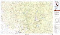
 2021 Millerton Lake West2021 Print · USGSMadera County’s foothills meet the rising waters of the San Joaquin River in this recent survey. Local historians can trace the topography surrounding Millerton Lake, find the small settlement of Hildreth, and follow the Buzzard's Roost Trl.
End of results
Showing maps 1-16 of 16
Top cities near Hildreth
Frequently asked questions
- What are the different types of historical maps available for Hildreth?
- What is the oldest map of Hildreth?
- Where can I purchase historical maps of Hildreth for my home or office?
- Where can I download high-res historical maps of Hildreth?
- Are there historical topographic maps available for Hildreth?
- Is there historical aerial imagery available for Hildreth?
- Where are historical maps of Hildreth sourced from?