1960s Maps of Yosemite Lakes, California
Explore 5 historic maps of Yosemite Lakes from the 1960s. These maps offer a rare glimpse into what life looked like during the 1960s — showing old roads, neighborhoods, homes, and landmarks that have changed or disappeared over time.
Whether you're researching your family's past, planning a metal detecting trip, or studying how Yosemite Lakes's landscape evolved across the 1960s, these high-resolution maps are a powerful tool for exploring the history of this region.
- Focus on a specific era: All maps on this page are from the 1960s, giving you a focused view of this time period.
- See what’s changed: Compare century-old streets, trails, and buildings to today's modern landscape using overlays and satellite layers.
- Research with precision: Use these maps for genealogy, historical research, land use analysis, or educational projects.
- View, download, or print: Maps are fully viewable online in high resolution, and can be downloaded or printed for your own records.
Start exploring Yosemite Lakes's history through authentic maps from the 1960s. This is your window into the past.
Yosemite Lakes, CA maps
(5)- 1962 Map of Knowles, 1963 Print
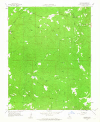 1962 Knowles1963 Print · USGSMadera County’s granite-quarrying heartland is documented here in the early sixties, showing the vital connection between the land and its stone industry. Researchers can find old industrial sites like the Raymond Quarry, local landmarks such as Savage Monument, and the grounds of the San Joaquin Experimental Range.2 unique versions available
 - 1962 Map of Raymond, 1964 Print
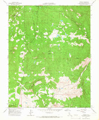
 1962 Raymond1964 Print · USGSMadera County foothills in the early sixties reveal a landscape of granite quarries and historic ranching outposts. Genealogists and historians can trace family-named sites like Twentytwo Mile House, Adobe Ranch, and the Raymond Cemetery.
 - 1963 Map of Mariposa
 1963 Mariposa1963 Print · USGSThe High Sierra and Owens Valley meet in the early sixties, showing a landscape defined by gold-rush history and massive post-war water projects. Genealogists and researchers can trace old mining routes near Mariposa, locate the Glacier Point Hotel, and find small settlements like Coarse Gold or Knowles Junction.
 - 1965 Map of O'Neals, 1966 Print
 1965 O'Neals1966 Print · USGSThe Madera County foothills are mapped here in the mid-1960s, showing a region of sprawling ranches and historic mining claims. Researchers can trace family history at the Picayune Cem or locate operations like the Quartz Mine and the 101 Ranch.2 unique versions available
 - 1965 Map of Millerton Lake, 1967 Print
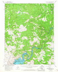 1965 Millerton Lake1967 Print · USGSThe San Joaquin foothills in the mid-sixties reveal a landscape of family ranches and new reservoirs. Genealogists can trace family landmarks like Veater Ranch and O'Neals, or locate the historic Picayune Cem and Spring Valley Sch.2 unique versions available
End of results
Showing maps 1-5 of 5
Top cities near Yosemite Lakes
Top neighborhoods of Yosemite Lakes
Frequently asked questions
- What are the different types of historical maps available for Yosemite Lakes?
- What is the oldest map of Yosemite Lakes?
- Where can I purchase historical maps of Yosemite Lakes for my home or office?
- Where can I download high-res historical maps of Yosemite Lakes?
- Are there historical topographic maps available for Yosemite Lakes?
- Is there historical aerial imagery available for Yosemite Lakes?
- Where are historical maps of Yosemite Lakes sourced from?