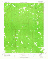
1962 Map of Knowles
USGS Topo · Published 1963About this map
Knowles and the surrounding granite-rich landscape of Madera County are captured here in the early 1960s, a period when the area's quarrying tradition remained a defining characteristic of the local economy. The presence of the Raymond Quarry and Madera Quarry highlights the industrial importance of this region, which provided stone for major architectural projects across California. The terrain is marked by the winding path of the Fresno River and numerous drainages like Coarse Gold Creek and Whisky Creek, which flow through canyons such as Wild Hog Canyon and Buzzard Canyon. High points like Lilley Mtn and Adkins Mtn provide context for the elevation, while the Red Top Lookout and Savage Monument serve as local landmarks. The southeastern portion of the map includes a section of the San Joaquin Experimental Range, illustrating the intersection of mining, ranching, and land management in this Sierra Nevada foothill environment.
Find a feature on this map
29 named features on this map. Tap any name to fly to it.
Don’t see what you’re looking for? This feature index may not catch every label — zoom into the map to look around manually.
Map Details
Editions of this 1962 Knowles Map
2 editions found
Other maps of this area

1912 · Mariposa
USGS Topo · 1:125,000

1916 · Sulphur Springs
USGS Topo · 1:24,000

1919 · Sulphur Springs
USGS Topo · 1:31,680

1919 · Little Table Mountain
USGS Topo · 1:31,680

1921 · Daulton
USGS Topo · 1:31,680

1942 · Raymond
USGS Topo · 1:62,500

1942 · Daulton
USGS Topo · 1:24,000

1942 · Little Table Mountain
USGS Topo · 1:24,000

1942 · Millerton Lake
USGS Topo · 1:62,500

1944 · Raymond
USGS Topo · 1:62,500