1910s Maps of Seahaven, California
Explore 2 historic maps of Seahaven from the 1910s. These maps offer a rare glimpse into what life looked like during the 1910s — showing old roads, neighborhoods, homes, and landmarks that have changed or disappeared over time.
Whether you're researching your family's past, planning a metal detecting trip, or studying how Seahaven's landscape evolved across the 1910s, these high-resolution maps are a powerful tool for exploring the history of this region.
- Focus on a specific era: All maps on this page are from the 1910s, giving you a focused view of this time period.
- See what’s changed: Compare century-old streets, trails, and buildings to today's modern landscape using overlays and satellite layers.
- Research with precision: Use these maps for genealogy, historical research, land use analysis, or educational projects.
- View, download, or print: Maps are fully viewable online in high resolution, and can be downloaded or printed for your own records.
Start exploring Seahaven's history through authentic maps from the 1910s. This is your window into the past.
Seahaven, CA maps
(2)- 1916 Map of Point Reyes
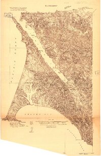 1916 Point Reyes1916 Print · USGSCoastal Marin County during the mid-1910s reveals a working landscape of shorefront landings and family ranches. Researchers can trace early settlements and schools like Lairds Landing, Olema, and Franklin School before modern park designations.2 unique versions available
 - 1918 Map of Point Reyes
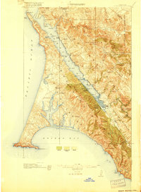 1918 Point Reyes1918 Print · USGSMarin County's rugged coast appears here in the years following the turn of the century, showing a working landscape of ranches and rail. Genealogists can locate family landmarks like Lairds Landing, rural schoolhouses, and the Northwestern Pacific line.6 unique versions available
End of results
Showing maps 1-2 of 2
Top cities near Seahaven
- San Francisco historical maps
- Petaluma historical maps
- Rohnert Park historical maps
- Cotati historical maps
Frequently asked questions
- What are the different types of historical maps available for Seahaven?
- What is the oldest map of Seahaven?
- Where can I purchase historical maps of Seahaven for my home or office?
- Where can I download high-res historical maps of Seahaven?
- Are there historical topographic maps available for Seahaven?
- Is there historical aerial imagery available for Seahaven?
- Where are historical maps of Seahaven sourced from?