Old Maps of McClure Place, California for Hiking & Exploration
Hike through history with 11 historic maps of McClure Place. Explore old trails, ghost towns, and forgotten backroads — perfect for outdoor adventurers and local explorers.
- Rediscover forgotten places: Map out old mining camps, roads, and footpaths that no longer exist on modern maps.
- Layer with modern tools: Combine with LiDAR or satellite views to plan hikes through historical terrain.
- Made for exploration: Popular among hikers, overlanders, and local history lovers.
Use these maps to find adventure and explore the hidden past of McClure Place.
McClure Place, CA maps
(11)- 1926 Map of Covelo
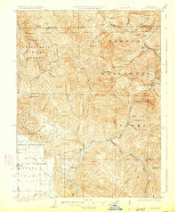 1926 Covelo1926 Print · USGSThe isolated high valley of Covelo is captured here in the mid-1920s, surrounded by the wilderness of the California National Forest. Local historians can locate the Indian School, early ranger outposts, and family landmarks like Browns Ranch.2 unique versions available
 - 1952 Map of Covelo, 1954 Print
 1952 Covelo1954 Print · USGSRound Valley in the early fifties remains a rugged hub of Mendocino ranching and indigenous life centered on the Covelo township. Genealogists and local historians can trace the foundations of the community at the Reservation School, Nomlackie Cem, and family landmarks like the Bauer Ranch.4 unique versions available
 - 1957 Map of Ukiah, 1966 Print
 1957 Ukiah1966 Print · USGSNorthern California's diverse terrain comes into focus in the mid-1950s, from the rugged timberlands of the Jackson State Forest to the productive Sacramento Valley. Genealogists and historians can trace the rail lines of the Northwestern Pacific or locate early valley settlements like Arbuckle and Paskenta.3 unique versions available
 - 1960 Map of Ukiah
 1960 Ukiah1960 Print · USGSNorthern California during the late fifties reveals a landscape of deep timber forests and valley agriculture before modern expansion. Trace the historic rail lines of the California Western RR and the Northwestern Pacific RR through settlements like Fort Bragg and Ukiah.2 unique versions available
 - 1967 Map of Newhouse Ridge, 1969 Print
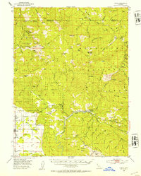
 1967 Newhouse Ridge1969 Print · USGSMendocino National Forest in the late 1960s was a rugged network of forest service stations and remote ranching outposts. Researchers can trace historic pack trails leading to McClure Place, Bauer Ranch, and the Eel River Station.2 unique versions available
 - 1981 Map of Covelo
 1981 Covelo1981 Print · USGSIn the early 1980s, Mendocino County's interior and coastline remained a patchwork of tribal lands and timber outposts. Trace the Northwestern Pacific rail line and discover the boundaries of the Round Valley Indian Reservation Boundary and Covelo.2 unique versions available
 - 1995 Map of Newhouse Ridge, 2001 Print
 1995 Newhouse Ridge2001 Print · USGSThe Mendocino mountains in the mid-1990s show a landscape of deep river canyons and high forestry outposts. Genealogists and hikers can trace the paths around Eel River Work Center, the remote Capistran Ranch, and landmarks like Nebo Rock.
 - 2012 Map of Newhouse Ridge, 2012 Print
 2012 Newhouse Ridge2012 Print · USGSCovers McClure Place, including Mendocino County, United States, and other nearby areas
 - 2015 Map of Newhouse Ridge, 2015 Print
 2015 Newhouse Ridge2015 Print · USGSCovers McClure Place, including Mendocino County, United States, and other nearby areas
 - 2018 Map of Newhouse Ridge, 2018 Print
 2018 Newhouse Ridge2018 Print · USGSCovers McClure Place, including Mendocino County, United States, and other nearby areas
 - 2021 Map of Newhouse Ridge, 2021 Print
 2021 Newhouse Ridge2021 Print · USGSMendocino County's high forest terrain is captured here during the early 2020s, dominated by the protected corridors of the Eel and Black Butte Wild and Scenic Rivers. Trace remote landmarks like Shake Cabin Flat, Nebo Rock, and the waters of Bucknell Spring.
End of results
Showing maps 1-11 of 11
Frequently asked questions
- What are the different types of historical maps available for McClure Place?
- What is the oldest map of McClure Place?
- Where can I purchase historical maps of McClure Place for my home or office?
- Where can I download high-res historical maps of McClure Place?
- Are there historical topographic maps available for McClure Place?
- Is there historical aerial imagery available for McClure Place?
- Where are historical maps of McClure Place sourced from?