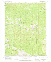
1967 Map of Newhouse Ridge
USGS Topo · Published 1969About this map
Mendocino National Forest encompasses this landscape where the Middle Fork Eel River and the Black Butte River converge. The terrain is defined by complex ridges such as Etsel Ridge, Newhouse Ridge, and Anthony Ridge, which dictate the paths of numerous pack trails and jeep roads used for fire management and backcountry access. Scattered evidence of human activity is found at isolated outposts like the McClure Place and Bauer Ranch, illustrating the remote nature of 1960s ranching and land management in this part of California.
Find a feature on this map
65 named features on this map. Tap any name to fly to it.
Don’t see what you’re looking for? This feature index may not catch every label — zoom into the map to look around manually.
Map Details
Editions of this 1967 Newhouse Ridge Map
2 editions found
Other maps of this area

1926 · Covelo
USGS Topo · 1:62,500

1929 · Eden Valley
USGS Topo · 1:62,500

1952 · Hull Mountain
USGS Topo · 1:62,500

1952 · Eden Valley
USGS Topo · 1:62,500

1952 · Covelo
USGS Topo · 1:62,500

1952 · Anthony Peak
USGS Topo · 1:62,500

1957 · Ukiah
USGS Topo · 1:250,000

1960 · Ukiah
USGS Topo · 1:250,000
1966 · Leech Lake Mountain
USGS Topo · 1:24,000

1967 · Plaskett Ridge
USGS Topo · 1:24,000