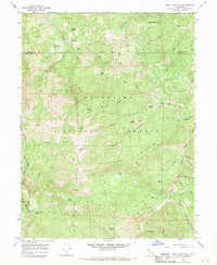
1966 Map of Leech Lake Mountain
USGS Topo · Published 1969About this map
Mendocino National Forest is defined by its network of historic pack trails and seasonal outposts throughout this mid-1960s survey. Significant land features like Leech Lake Mtn and Hammerhorn Ridge rise above the Middle Fork Eel River, while localized names such as Osborn Station, Foster Ranch, and Reeves Place hint at the human activity within the diminished portion of the Round Valley Indian Reservation. The map documents a wilderness economy of remote lodges and transit points, including Hotel Camp, Travelers Home, and the eponymous Leech Lake. Extensive Pack Trail and Jeep Trail routes connect high-elevation landmarks like Airplane Meadow and Castle Peak, providing a detailed record of the forest's access points before modern development patterns fully emerged in this part of Trinity and Mendocino Counties.
Find a feature on this map
54 named features on this map. Tap any name to fly to it.
Don’t see what you’re looking for? This feature index may not catch every label — zoom into the map to look around manually.
Map Details
Editions of this 1966 Leech Lake Mountain Map
3 editions found
Other maps of this area

1890 · Red Bluff
USGS Topo · 1:250,000

1894 · Red Bluff
USGS Topo · 1:250,000

1926 · Covelo
USGS Topo · 1:62,500

1931 · Hoaglin
USGS Topo · 1:96,000

1935 · Hoaglin
USGS Topo · 1:125,000

1952 · Covelo
USGS Topo · 1:62,500

1952 · Anthony Peak
USGS Topo · 1:62,500

1953 · Blackrock Mtn
USGS Topo · 1:62,500

1954 · Blackrock Mtn
USGS Topo · 1:62,500

1954 · Yolla Bolly
USGS Topo · 1:62,500