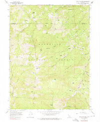
1966 Map of Leech Lake Mountain
USGS Topo · Published 1976About this map
The Middle Fork Eel River cuts through the Mendocino and Trinity county lines, defining a landscape dominated by the Mendocino National Forest. This 1966 survey records a network of remote outposts and family-named landmarks that speak to the region's ranching and transit history, including Foster Ranch, Reeves Place, and the curious nomenclature of Travelers Home. The terrain is characterized by high ridges and distinct geological markers such as Castle Peak and the namesake Leech Lake Mtn.
Find a feature on this map
53 named features on this map. Tap any name to fly to it.
Don’t see what you’re looking for? This feature index may not catch every label — zoom into the map to look around manually.
Map Details
Editions of this 1966 Leech Lake Mountain Map
3 editions found
Other maps of this area

1890 · Red Bluff
USGS Topo · 1:250,000

1894 · Red Bluff
USGS Topo · 1:250,000

1926 · Covelo
USGS Topo · 1:62,500

1931 · Hoaglin
USGS Topo · 1:96,000

1935 · Hoaglin
USGS Topo · 1:125,000

1952 · Covelo
USGS Topo · 1:62,500

1952 · Anthony Peak
USGS Topo · 1:62,500

1953 · Blackrock Mtn
USGS Topo · 1:62,500

1954 · Blackrock Mtn
USGS Topo · 1:62,500

1954 · Yolla Bolly
USGS Topo · 1:62,500