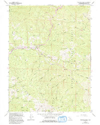
1967 Map of Newhouse Ridge
USGS Topo · Published 1994About this map
The Mendocino National Forest defines this high-elevation landscape where the Middle Fork Eel River and Black Butte River converge. This area is characterized by a network of ridges and basins, including Etsel Ridge, Newhouse Ridge, and Hayshed Basin. Human activity is concentrated around administrative and recreational sites like the Eel River Work Center and the Eel River Campground. The geography reveals a history of land use through family-named features such as McClure Place, George Lambert Ridge, and Sallady Ridge.
Find a feature on this map
50 named features on this map. Tap any name to fly to it.
Don’t see what you’re looking for? This feature index may not catch every label — zoom into the map to look around manually.
Map Details
Editions of this 1967 Newhouse Ridge Map
2 editions found
Other maps of this area

1926 · Covelo
USGS Topo · 1:62,500

1929 · Eden Valley
USGS Topo · 1:62,500

1952 · Hull Mountain
USGS Topo · 1:62,500

1952 · Eden Valley
USGS Topo · 1:62,500

1952 · Covelo
USGS Topo · 1:62,500

1952 · Anthony Peak
USGS Topo · 1:62,500

1957 · Ukiah
USGS Topo · 1:250,000

1960 · Ukiah
USGS Topo · 1:250,000
1966 · Leech Lake Mountain
USGS Topo · 1:24,000

1967 · Plaskett Ridge
USGS Topo · 1:24,000