Old Maps of Piercy, California for Genealogy
Trace your family roots with 9 historic maps of Piercy. These high-res maps reveal old neighborhoods, homesites, landmarks, and streets — helping you uncover where your ancestors lived and how the area evolved over time.
- Explore historic neighborhoods: Identify where your relatives may have lived in the 1800s or 1900s.
- Compare maps over time: Trace the changes in streets, buildings, and landmarks for multi-generational research.
- Perfect for genealogy & ancestry research: Used by family historians and researchers to map out lineage and migration.
These maps are an incredible resource for exploring your personal connection to Piercy's past.
Piercy, CA maps
(9)- 1950 Map of Piercy, 1952 Print
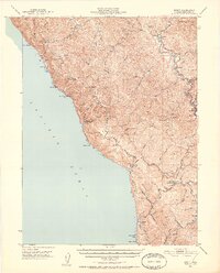 1950 Piercy1952 Print · USGSCoastal Mendocino County is shown here in the early fifties, documenting a landscape of isolated shore outposts and river settlements. Genealogists and historians can locate family ranches and sites like Hollow Tree (Hales Grove), Moody (Site), and the DeVilbiss Ranch.5 unique versions available
 - 1957 Map of Ukiah, 1966 Print
 1957 Ukiah1966 Print · USGSNorthern California's diverse terrain comes into focus in the mid-1950s, from the rugged timberlands of the Jackson State Forest to the productive Sacramento Valley. Genealogists and historians can trace the rail lines of the Northwestern Pacific or locate early valley settlements like Arbuckle and Paskenta.3 unique versions available
 - 1960 Map of Ukiah
 1960 Ukiah1960 Print · USGSNorthern California during the late fifties reveals a landscape of deep timber forests and valley agriculture before modern expansion. Trace the historic rail lines of the California Western RR and the Northwestern Pacific RR through settlements like Fort Bragg and Ukiah.2 unique versions available
 - 1969 Map of Piercy, 1973 Print
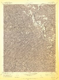 1969 Piercy1973 Print · USGSNorthern Mendocino County during the late sixties is centered on the river-cleft corridor of the South Fork Eel River. Researchers can trace the old locations of Andersonia and Moody or find the solitary Lilley Grave near the highway.4 unique versions available
 - 1981 Map of Covelo
 1981 Covelo1981 Print · USGSIn the early 1980s, Mendocino County's interior and coastline remained a patchwork of tribal lands and timber outposts. Trace the Northwestern Pacific rail line and discover the boundaries of the Round Valley Indian Reservation Boundary and Covelo.2 unique versions available
 - 2012 Map of Piercy, 2012 Print
 2012 Piercy2012 Print · USGSCovers Piercy, including Mendocino County, United States, and other nearby areas
 - 2015 Map of Piercy, 2015 Print
 2015 Piercy2015 Print · USGSCovers Piercy, including Mendocino County, United States, and other nearby areas
 - 2018 Map of Piercy, 2018 Print
 2018 Piercy2018 Print · USGSCovers Piercy, including Mendocino County, United States, and other nearby areas
 - 2021 Map of Piercy, 2021 Print
 2021 Piercy2021 Print · USGSThe South Fork Eel River corridor comes into focus in this late-modern era survey of Mendocino County. Genealogists can locate the Minnie Stoddard Lilley Gravesite or trace old routes like Old Mill Rd through Andersonia.
End of results
Showing maps 1-9 of 9
Top cities near Piercy
Frequently asked questions
- What are the different types of historical maps available for Piercy?
- What is the oldest map of Piercy?
- Where can I purchase historical maps of Piercy for my home or office?
- Where can I download high-res historical maps of Piercy?
- Are there historical topographic maps available for Piercy?
- Is there historical aerial imagery available for Piercy?
- Where are historical maps of Piercy sourced from?