1910s Maps of Atwater, California
Explore 3 historic maps of Atwater from the 1910s. These maps offer a rare glimpse into what life looked like during the 1910s — showing old roads, neighborhoods, homes, and landmarks that have changed or disappeared over time.
Whether you're researching your family's past, planning a metal detecting trip, or studying how Atwater's landscape evolved across the 1910s, these high-resolution maps are a powerful tool for exploring the history of this region.
- Focus on a specific era: All maps on this page are from the 1910s, giving you a focused view of this time period.
- See what’s changed: Compare century-old streets, trails, and buildings to today's modern landscape using overlays and satellite layers.
- Research with precision: Use these maps for genealogy, historical research, land use analysis, or educational projects.
- View, download, or print: Maps are fully viewable online in high resolution, and can be downloaded or printed for your own records.
Start exploring Atwater's history through authentic maps from the 1910s. This is your window into the past.
Atwater, CA maps
(3)- 1917 Map of Winton
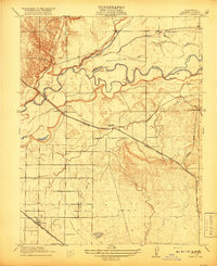 1917 Winton1917 Print · USGSMerced County agriculture was flourishing during the First World War as three major rail lines crossed the valley floor. Genealogists and local historians can trace early settlements at Winton and Amsterdam or locate rural landmarks like Hopeton School.2 unique versions available
 - 1918 Map of Arena
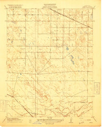 1918 Arena1918 Print · USGSMerced County agriculture and rural life are captured here during the First World War. Genealogists can locate family homesteads near country landmarks like Witmer School, Jordan School, and the village of Arena along the Southern Pacific tracks.2 unique versions available
 - 1918 Map of Atwater
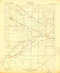 1918 Atwater1918 Print · USGSMerced County agriculture was flourishing during the First World War as rail lines and irrigation transformed the landscape. Researchers can trace early school districts like McSwain School and Franklin School alongside the competing tracks of the Southern Pacific and the Atchison Topeka and Santa Fe.
End of results
Showing maps 1-3 of 3
Top cities near Atwater
- Merced historical maps
- Turlock historical maps
- Livingston historical maps
- Delhi historical maps
- Winton historical maps
- Denair historical maps
See more
Top neighborhoods of Atwater
Frequently asked questions
- What are the different types of historical maps available for Atwater?
- What is the oldest map of Atwater?
- Where can I purchase historical maps of Atwater for my home or office?
- Where can I download high-res historical maps of Atwater?
- Are there historical topographic maps available for Atwater?
- Is there historical aerial imagery available for Atwater?
- Where are historical maps of Atwater sourced from?