1910s Maps of Merced Falls, California
Explore 2 historic maps of Merced Falls from the 1910s. These maps offer a rare glimpse into what life looked like during the 1910s — showing old roads, neighborhoods, homes, and landmarks that have changed or disappeared over time.
Whether you're researching your family's past, planning a metal detecting trip, or studying how Merced Falls's landscape evolved across the 1910s, these high-resolution maps are a powerful tool for exploring the history of this region.
- Focus on a specific era: All maps on this page are from the 1910s, giving you a focused view of this time period.
- See what’s changed: Compare century-old streets, trails, and buildings to today's modern landscape using overlays and satellite layers.
- Research with precision: Use these maps for genealogy, historical research, land use analysis, or educational projects.
- View, download, or print: Maps are fully viewable online in high resolution, and can be downloaded or printed for your own records.
Start exploring Merced Falls's history through authentic maps from the 1910s. This is your window into the past.
Merced Falls, CA maps
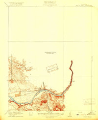
(2)- 1916 Map of Merced Falls, 1957 Print
 1916 Merced Falls1957 Print · USGSThe riverfront settlement of Merced Falls is captured here in the early twentieth century as a bustling industrial and transit hub. Researchers can trace the legacy of mining through the Tailings along the Merced River and follow historic routes like Old Mill Road.
 - 1919 Map of Merced Falls
 1919 Merced Falls1919 Print · USGSThe foothills of the Sierra Nevada meet the valley floor in the years following the gold rush, centered on the industrial activity at Merced Falls. Researchers can trace the early dredging era through Tailings along the Merced River and follow historic routes like Old Mill Road.3 unique versions available
End of results
Showing maps 1-2 of 2
Top cities near Merced Falls
Frequently asked questions
- What are the different types of historical maps available for Merced Falls?
- What is the oldest map of Merced Falls?
- Where can I purchase historical maps of Merced Falls for my home or office?
- Where can I download high-res historical maps of Merced Falls?
- Are there historical topographic maps available for Merced Falls?
- Is there historical aerial imagery available for Merced Falls?
- Where are historical maps of Merced Falls sourced from?