
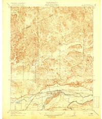
1916 Map of Merced Falls
USGS Topo · Published 1957About this map
Merced Falls serves as the focal point of this 1916 survey, situated where the Merced River defines the border between Mariposa and Merced counties. The landscape is marked by the industrial legacy of the region, specifically noted by the presence of large Tailings deposits along the riverbanks, hinting at the extensive dredging or mining operations active during this era. Local transportation is anchored by historic thoroughfares like Hornitos Road and Old Mill Road, which connect the riverside settlement to the surrounding hills.
Find a feature on this map
10 named features on this map. Tap any name to fly to it.
Don’t see what you’re looking for? This feature index may not catch every label — zoom into the map to look around manually.
Map Details
Editions of this 1916 Merced Falls Map
This is the sole edition of this map. No revisions or reprints were ever made.
Other maps of this area

1893 · Sonora
USGS Topo · 1:125,000

1896 · Sonora
USGS Topo · 1:125,000

1897 · Sonora
USGS Topo · 1:125,000

1898 · Sonora
USGS Topo · 1:125,000

1915 · La Grange
USGS Topo · 1:24,000

1916 · Hopeton
USGS Topo · 1:31,680
1918 · Snelling
USGS Topo · 1:31,680

1919 · Indian Gulch
USGS Topo · 1:48,000

1919 · Haystack Mountain
USGS Topo · 1:31,680

1919 · La Grange
USGS Topo · 1:31,680