1940s Maps of Merced, California
Explore 8 historic maps of Merced from the 1940s. These maps offer a rare glimpse into what life looked like during the 1940s — showing old roads, neighborhoods, homes, and landmarks that have changed or disappeared over time.
Whether you're researching your family's past, planning a metal detecting trip, or studying how Merced's landscape evolved across the 1940s, these high-resolution maps are a powerful tool for exploring the history of this region.
- Focus on a specific era: All maps on this page are from the 1940s, giving you a focused view of this time period.
- See what’s changed: Compare century-old streets, trails, and buildings to today's modern landscape using overlays and satellite layers.
- Research with precision: Use these maps for genealogy, historical research, land use analysis, or educational projects.
- View, download, or print: Maps are fully viewable online in high resolution, and can be downloaded or printed for your own records.
Start exploring Merced's history through authentic maps from the 1940s. This is your window into the past.
Merced, CA maps
(8)- 1946 Map of Sandy Mush, 1947 Print
 1946 Sandy Mush1947 Print · USGSMerced County agriculture is in full bloom in the mid-1940s, showing a landscape defined by windmills and winding sloughs. Genealogists and researchers can trace the area's rural development through the Lone Tree Sch, Potter Field, and the historic Sandy Mush and Athlone Road.
 - 1946 Map of Merced, 1954 Print
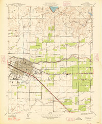
 1946 Merced1954 Print · USGSMid-century Merced and its surrounding farm colonies are captured here just after the war, showing the area's transition into a regional agricultural powerhouse. Genealogists can locate family-named landmarks and rural education sites like Merced Colony School and the settlement of Creegan.
 - 1946 Map of Santa Rita Park, 1954 Print
 1946 Santa Rita Park1954 Print · USGSThe San Joaquin Valley's intricate network of sloughs and early irrigation canals is captured here as the ranching economy thrived after the war. Family historians can trace dozens of named estates and local landmarks like Santa Rita Park, Lone Tree Sch, and Wolfsen Mill.
 - 1947 Map of San Jose, 1948 Print
 1947 San Jose1948 Print · USGSNorthern California's heartland is captured here just after the war, showing the rapid growth of the Santa Clara and Central Valleys. Researchers can trace the legacy of rail and water at Castle Air Force Base, Stockton, and the Hetch Hetchy Aqueduct.
 - 1948 Map of Sandy Mush
 1948 Sandy Mush1948 Print · USGSSandy Mush and the surrounding Merced County ranchlands are captured here in the late 1940s, showing a landscape defined by water management. Genealogists and historians can trace family-named roads like El Nido Road and find the site of the Lone Tree Sch.
 - 1948 Map of Yosemite Lake
 1948 Yosemite Lake1948 Print · USGSMerced County agriculture and infrastructure are on display here in the late 1940s as the regional irrigation system reached maturity. Researchers can trace the path of the Main Canal through Tunnel No 1 and locate old thoroughfares like the Snelling and Hornitos Road.
 - 1948 Map of Merced
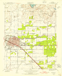
 1948 Merced1948 Print · USGSMerced and its agricultural outskirts are captured in the late 1940s as a bustling railroad and institutional center. Genealogists and historians can trace family-named schools and small rail stops like Merced Colony Sch, Tuttle, and Bellevue Ranch.
 - 1948 Map of Atwater
 1948 Atwater1948 Print · USGSThe Central Valley's agricultural and military landscape is captured here in the late 1940s as irrigation and aviation began to reshape the region. Local historians can trace family-named roads and rural schoolhouses like Buhach Sch and Eschscholtzia Sch alongside Castle Field.2 unique versions available
End of results
Showing maps 1-8 of 8
Top cities near Merced
- Atwater historical maps
- Chowchilla historical maps
- Winton historical maps
- Planada historical maps
- Le Grand historical maps
- Cressey historical maps
Top neighborhoods of Merced
Frequently asked questions
- What are the different types of historical maps available for Merced?
- What is the oldest map of Merced?
- Where can I purchase historical maps of Merced for my home or office?
- Where can I download high-res historical maps of Merced?
- Are there historical topographic maps available for Merced?
- Is there historical aerial imagery available for Merced?
- Where are historical maps of Merced sourced from?