1960s Maps of Merced, California
Explore 9 historic maps of Merced from the 1960s. These maps offer a rare glimpse into what life looked like during the 1960s — showing old roads, neighborhoods, homes, and landmarks that have changed or disappeared over time.
Whether you're researching your family's past, planning a metal detecting trip, or studying how Merced's landscape evolved across the 1960s, these high-resolution maps are a powerful tool for exploring the history of this region.
- Focus on a specific era: All maps on this page are from the 1960s, giving you a focused view of this time period.
- See what’s changed: Compare century-old streets, trails, and buildings to today's modern landscape using overlays and satellite layers.
- Research with precision: Use these maps for genealogy, historical research, land use analysis, or educational projects.
- View, download, or print: Maps are fully viewable online in high resolution, and can be downloaded or printed for your own records.
Start exploring Merced's history through authentic maps from the 1960s. This is your window into the past.
Merced, CA maps
(9)- 1960 Map of Atwater, 1961 Print
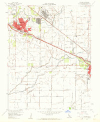 1960 Atwater1961 Print · USGSAtwater and the outskirts of Merced are seen here at the dawn of the sixties, characterized by a mix of military presence and intensive irrigation. Trace the evolution of Castle Air Force Base or locate local landmarks like the County Honor Farm and McSwain School.4 unique versions available
 - 1961 Map of Merced, 1963 Print
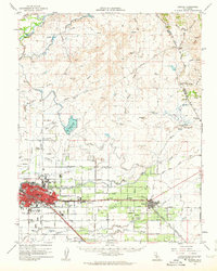
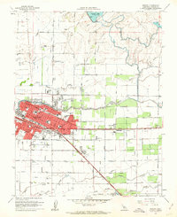 1961 Merced1963 Print · USGSMerced at the start of the 1960s reveals a growing Central Valley hub defined by its busy rail corridors and neighborhood schools. Genealogists can locate family sites near Evergreen Cemetery, Applegate Park, and landmark institutions like Our Lady of Mercy School.3 unique versions available
 - 1961 Map of Atwater, 1963 Print
 1961 Atwater1963 Print · USGSThe San Joaquin Valley's agricultural and military landscape comes alive in the early sixties as the jet age meets established rail towns. Local historians can trace the development of Castle Air Force Base and find local landmarks like Hopeton Cem, Shaffer Bridge, and numerous rural schools.2 unique versions available
 - 1962 Map of San Jose
 1962 San Jose1962 Print · USGSCentral California in the early sixties showcases the expansion of the San Joaquin and Santa Clara valleys. Researchers can trace the rail-to-road transition along the Southern Pacific RR or locate landmarks like Castle USAF Base and Loma Prieta.4 unique versions available
 - 1962 Map of Yosemite Lake, 1963 Print
 1962 Yosemite Lake1963 Print · USGSMerced County agriculture and recreation are in focus during the early sixties as irrigation systems expanded across the valley. Researchers can trace the Old Railroad Grade, the settlement of Youd, and the engineered waters of Yosemite Lake.4 unique versions available
 - 1962 Map of Merced, 1963 Print
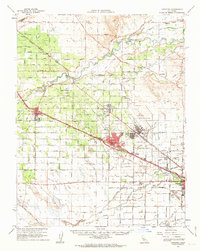
 1962 Merced1963 Print · USGSMerced and the surrounding San Joaquin Valley are captured in the early sixties, showing a landscape defined by industrial agriculture and the steel rails of two major railroads. Genealogists and historians can trace family-named properties like La Paloma Ranch or locate local landmarks like Calvary Cem and Planada.
 - 1962 Map of Santa Rita Park, 1963 Print
 1962 Santa Rita Park1963 Print · USGSMerced County ranchlands and the Central Valley's complex water network are documented here in the early sixties. Genealogists and local historians can trace legacy holdings like the Miller and Lux Ranch or locate the Flynn Duck Club and Santa Rita Park.
 - 1962 Map of Sandy Mush, 1963 Print
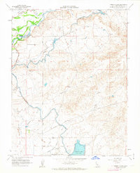
 1962 Sandy Mush1963 Print · USGSMerced County in the early 1960s was a landscape defined by its intricate waterways and emerging wildlife protections. Genealogists and historians can trace family road names and remote sites like Sandy Mush Ranch, the Merced National Wildlife Refuge, and Turner Island.
 - 1966 Map of San Jose
 1966 San Jose1966 Print · USGSCentral California in the mid-1960s reveals a landscape of massive irrigation projects and expanding Cold War military footprints. Researchers can trace the rail-and-river network of the San Joaquin Valley or locate specialized sites like Castle Air Force Base and the Sharp General Depot (Military).
End of results
Showing maps 1-9 of 9
Top cities near Merced
- Atwater historical maps
- Chowchilla historical maps
- Winton historical maps
- Planada historical maps
- Le Grand historical maps
- Cressey historical maps
Top neighborhoods of Merced
Frequently asked questions
- What are the different types of historical maps available for Merced?
- What is the oldest map of Merced?
- Where can I purchase historical maps of Merced for my home or office?
- Where can I download high-res historical maps of Merced?
- Are there historical topographic maps available for Merced?
- Is there historical aerial imagery available for Merced?
- Where are historical maps of Merced sourced from?