Old Maps of Merced, California for Genealogy
Trace your family roots with 40 historic maps of Merced. These high-res maps reveal old neighborhoods, homesites, landmarks, and streets — helping you uncover where your ancestors lived and how the area evolved over time.
- Explore historic neighborhoods: Identify where your relatives may have lived in the 1800s or 1900s.
- Compare maps over time: Trace the changes in streets, buildings, and landmarks for multi-generational research.
- Perfect for genealogy & ancestry research: Used by family historians and researchers to map out lineage and migration.
These maps are an incredible resource for exploring your personal connection to Merced's past.
Merced, CA maps
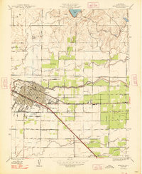
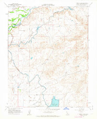
(40)- 1914 Map of Merced
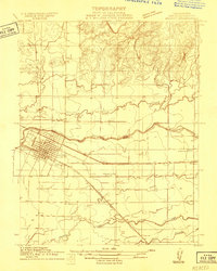 1914 Merced1914 Print · USGSMerced and its surrounding farm colonies are captured in the early twentieth century as the railroad era transformed the valley. Genealogists and researchers can trace local landmarks like Farmdale School, the Merced County Hospital, and the small settlement at Tuttle.
 - 1916 Map of Hopeton
 1916 Hopeton1916 Print · USGSMerced County agriculture and infrastructure are in focus here during the mid-1910s. Researchers can locate the Rotterdam School, trace the path of the Crocker Hoffman Canal, and see the early layout of Hopeton near the Merced River.
 - 1917 Map of Merced
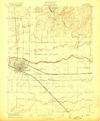 1917 Merced1917 Print · USGSMerced was a bustling rail and agricultural center during the First World War era. Genealogists and local historians can locate early landmarks like the Merced County Hospital, the Bellevue Ranch, and several rural schoolhouses such as Farmdale School.
 - 1918 Map of Atwater
 1918 Atwater1918 Print · USGSMerced County agriculture was flourishing during the First World War as rail lines and irrigation transformed the landscape. Researchers can trace early school districts like McSwain School and Franklin School alongside the competing tracks of the Southern Pacific and the Atchison Topeka and Santa Fe.
 - 1918 Map of Sandy Mush
 1918 Sandy Mush1918 Print · USGSMerced County during the first World War era was a landscape of expanding agricultural infrastructure and seasonal watercourses. Genealogists and historians can trace early property improvements through dozens of noted wells and landmarks like the Lone Tree School and the Sandy Mush and Athlone Road.
 - 1946 Map of Sandy Mush, 1947 Print
 1946 Sandy Mush1947 Print · USGSMerced County agriculture is in full bloom in the mid-1940s, showing a landscape defined by windmills and winding sloughs. Genealogists and researchers can trace the area's rural development through the Lone Tree Sch, Potter Field, and the historic Sandy Mush and Athlone Road.
 - 1946 Map of Merced, 1954 Print
 1946 Merced1954 Print · USGSMid-century Merced and its surrounding farm colonies are captured here just after the war, showing the area's transition into a regional agricultural powerhouse. Genealogists can locate family-named landmarks and rural education sites like Merced Colony School and the settlement of Creegan.
 - 1946 Map of Santa Rita Park, 1954 Print
 1946 Santa Rita Park1954 Print · USGSThe San Joaquin Valley's intricate network of sloughs and early irrigation canals is captured here as the ranching economy thrived after the war. Family historians can trace dozens of named estates and local landmarks like Santa Rita Park, Lone Tree Sch, and Wolfsen Mill.
 - 1947 Map of San Jose, 1948 Print
 1947 San Jose1948 Print · USGSNorthern California's heartland is captured here just after the war, showing the rapid growth of the Santa Clara and Central Valleys. Researchers can trace the legacy of rail and water at Castle Air Force Base, Stockton, and the Hetch Hetchy Aqueduct.
 - 1948 Map of Sandy Mush
 1948 Sandy Mush1948 Print · USGSSandy Mush and the surrounding Merced County ranchlands are captured here in the late 1940s, showing a landscape defined by water management. Genealogists and historians can trace family-named roads like El Nido Road and find the site of the Lone Tree Sch.
 - 1948 Map of Yosemite Lake
 1948 Yosemite Lake1948 Print · USGSMerced County agriculture and infrastructure are on display here in the late 1940s as the regional irrigation system reached maturity. Researchers can trace the path of the Main Canal through Tunnel No 1 and locate old thoroughfares like the Snelling and Hornitos Road.
 - 1948 Map of Merced
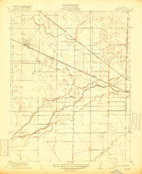
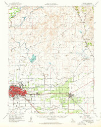
 1948 Merced1948 Print · USGSMerced and its agricultural outskirts are captured in the late 1940s as a bustling railroad and institutional center. Genealogists and historians can trace family-named schools and small rail stops like Merced Colony Sch, Tuttle, and Bellevue Ranch.
 - 1948 Map of Atwater
 1948 Atwater1948 Print · USGSThe Central Valley's agricultural and military landscape is captured here in the late 1940s as irrigation and aviation began to reshape the region. Local historians can trace family-named roads and rural schoolhouses like Buhach Sch and Eschscholtzia Sch alongside Castle Field.2 unique versions available
 - 1956 Map of San Jose
 1956 San Jose1956 Print · USGSCentral California in the mid-fifties reveals the transition from sprawling orchards to growing urban hubs like San Jose and Stockton. Genealogists and historians can trace the rail-era landscape of the Mother Lode through Chinese Camp and Tuttletown, or follow the water through the Joaquin River and Calaveras Reservoir.
 - 1960 Map of Atwater, 1961 Print
 1960 Atwater1961 Print · USGSAtwater and the outskirts of Merced are seen here at the dawn of the sixties, characterized by a mix of military presence and intensive irrigation. Trace the evolution of Castle Air Force Base or locate local landmarks like the County Honor Farm and McSwain School.4 unique versions available
 - 1961 Map of Merced, 1963 Print
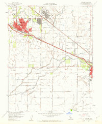
 1961 Merced1963 Print · USGSMerced at the start of the 1960s reveals a growing Central Valley hub defined by its busy rail corridors and neighborhood schools. Genealogists can locate family sites near Evergreen Cemetery, Applegate Park, and landmark institutions like Our Lady of Mercy School.3 unique versions available
 - 1961 Map of Atwater, 1963 Print
 1961 Atwater1963 Print · USGSThe San Joaquin Valley's agricultural and military landscape comes alive in the early sixties as the jet age meets established rail towns. Local historians can trace the development of Castle Air Force Base and find local landmarks like Hopeton Cem, Shaffer Bridge, and numerous rural schools.2 unique versions available
 - 1962 Map of San Jose
 1962 San Jose1962 Print · USGSCentral California in the early sixties showcases the expansion of the San Joaquin and Santa Clara valleys. Researchers can trace the rail-to-road transition along the Southern Pacific RR or locate landmarks like Castle USAF Base and Loma Prieta.4 unique versions available
 - 1962 Map of Yosemite Lake, 1963 Print
 1962 Yosemite Lake1963 Print · USGSMerced County agriculture and recreation are in focus during the early sixties as irrigation systems expanded across the valley. Researchers can trace the Old Railroad Grade, the settlement of Youd, and the engineered waters of Yosemite Lake.4 unique versions available
 - 1962 Map of Merced, 1963 Print
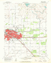
 1962 Merced1963 Print · USGSMerced and the surrounding San Joaquin Valley are captured in the early sixties, showing a landscape defined by industrial agriculture and the steel rails of two major railroads. Genealogists and historians can trace family-named properties like La Paloma Ranch or locate local landmarks like Calvary Cem and Planada.
 - 1962 Map of Santa Rita Park, 1963 Print
 1962 Santa Rita Park1963 Print · USGSMerced County ranchlands and the Central Valley's complex water network are documented here in the early sixties. Genealogists and local historians can trace legacy holdings like the Miller and Lux Ranch or locate the Flynn Duck Club and Santa Rita Park.
 - 1962 Map of Sandy Mush, 1963 Print
 1962 Sandy Mush1963 Print · USGSMerced County in the early 1960s was a landscape defined by its intricate waterways and emerging wildlife protections. Genealogists and historians can trace family road names and remote sites like Sandy Mush Ranch, the Merced National Wildlife Refuge, and Turner Island.
 - 1966 Map of San Jose
 1966 San Jose1966 Print · USGSCentral California in the mid-1960s reveals a landscape of massive irrigation projects and expanding Cold War military footprints. Researchers can trace the rail-and-river network of the San Joaquin Valley or locate specialized sites like Castle Air Force Base and the Sharp General Depot (Military).
 - 1983 Map of Merced
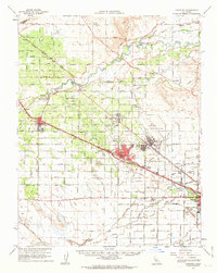
 1983 Merced1983 Print · USGSThe San Joaquin Valley at the start of the eighties is captured here in its full agricultural and military height. Trace the legacy of Castle Air Force Base, old mines like Pocahontas Mine, and the vast Kesterson National Wildlife Refuge.
 - 2012 Map of Merced, 2012 Print
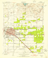
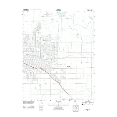 2012 Merced2012 Print · USGSCovers Merced, including Bear Creek, Bellevue Ranch, and other nearby areas
Showing maps 1-25 of 40
Top cities near Merced
- Atwater historical maps
- Chowchilla historical maps
- Winton historical maps
- Planada historical maps
- Le Grand historical maps
- Cressey historical maps
Top neighborhoods of Merced
Frequently asked questions
- What are the different types of historical maps available for Merced?
- What is the oldest map of Merced?
- Where can I purchase historical maps of Merced for my home or office?
- Where can I download high-res historical maps of Merced?
- Are there historical topographic maps available for Merced?
- Is there historical aerial imagery available for Merced?
- Where are historical maps of Merced sourced from?