1920s Maps of Santa Nella Village, California
Explore 2 historic maps of Santa Nella Village from the 1920s. These maps offer a rare glimpse into what life looked like during the 1920s — showing old roads, neighborhoods, homes, and landmarks that have changed or disappeared over time.
Whether you're researching your family's past, planning a metal detecting trip, or studying how Santa Nella Village's landscape evolved across the 1920s, these high-resolution maps are a powerful tool for exploring the history of this region.
- Focus on a specific era: All maps on this page are from the 1920s, giving you a focused view of this time period.
- See what’s changed: Compare century-old streets, trails, and buildings to today's modern landscape using overlays and satellite layers.
- Research with precision: Use these maps for genealogy, historical research, land use analysis, or educational projects.
- View, download, or print: Maps are fully viewable online in high resolution, and can be downloaded or printed for your own records.
Start exploring Santa Nella Village's history through authentic maps from the 1920s. This is your window into the past.
Santa Nella Village, CA maps
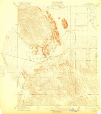
(2)- 1920 Map of Pacheco Pass
 1920 Pacheco Pass1920 Print · USGSThe Pacheco Pass gateway and the eastern Diablo Range are captured here during the early twentieth century. Researchers can trace historic local life through sites like the Bald Eagle Mine, San Luis Ranch, and Cottonwood School.4 unique versions available
 - 1922 Map of San Luis Creek
 1922 San Luis Creek1922 Print · USGSThe foothills of the San Joaquin Valley appear in this early twentieth-century survey, just as the ranching era was well-established. Genealogists and historians can trace old property lines through the San Luis Ranch and (Howard Ranch) or follow the path of Pacheco Pass Road.2 unique versions available
End of results
Showing maps 1-2 of 2
Top cities near Santa Nella Village
Frequently asked questions
- What are the different types of historical maps available for Santa Nella Village?
- What is the oldest map of Santa Nella Village?
- Where can I purchase historical maps of Santa Nella Village for my home or office?
- Where can I download high-res historical maps of Santa Nella Village?
- Are there historical topographic maps available for Santa Nella Village?
- Is there historical aerial imagery available for Santa Nella Village?
- Where are historical maps of Santa Nella Village sourced from?