1990s Maps of Lake City, California
Explore 2 historic maps of Lake City from the 1990s. These maps offer a rare glimpse into what life looked like during the 1990s — showing old roads, neighborhoods, homes, and landmarks that have changed or disappeared over time.
Whether you're researching your family's past, planning a metal detecting trip, or studying how Lake City's landscape evolved across the 1990s, these high-resolution maps are a powerful tool for exploring the history of this region.
- Focus on a specific era: All maps on this page are from the 1990s, giving you a focused view of this time period.
- See what’s changed: Compare century-old streets, trails, and buildings to today's modern landscape using overlays and satellite layers.
- Research with precision: Use these maps for genealogy, historical research, land use analysis, or educational projects.
- View, download, or print: Maps are fully viewable online in high resolution, and can be downloaded or printed for your own records.
Start exploring Lake City's history through authentic maps from the 1990s. This is your window into the past.
Lake City, CA maps
(2)- 1990 Map of Lake City
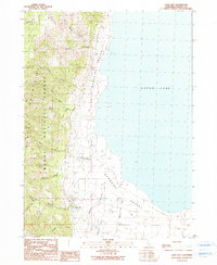 1990 Lake City1990 Print · USGSSurprise Valley was at a point of quiet stability in the late twentieth century, where the high Warner Mountains met the basin of Upper Lake. Researchers can trace local water rights and infrastructure through features like Lake City Mill South Fork and the Lake City Hot Springs.
 - 1993 Map of Lake City, 1996 Print
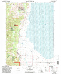 1993 Lake City1996 Print · USGSSurprise Valley and the Modoc high country are captured here in the mid-1990s, showing the transition from mountain forest to the high desert basin. Genealogists and local historians can trace the irrigation and water rights of Lake City through landmarks like the Lake City Hot Springs and Soldier Creek.
End of results
Showing maps 1-2 of 2
Top cities near Lake City
Frequently asked questions
- What are the different types of historical maps available for Lake City?
- What is the oldest map of Lake City?
- Where can I purchase historical maps of Lake City for my home or office?
- Where can I download high-res historical maps of Lake City?
- Are there historical topographic maps available for Lake City?
- Is there historical aerial imagery available for Lake City?
- Where are historical maps of Lake City sourced from?