1990s Maps of Lookout Junction, California
Explore 2 historic maps of Lookout Junction from the 1990s. These maps offer a rare glimpse into what life looked like during the 1990s — showing old roads, neighborhoods, homes, and landmarks that have changed or disappeared over time.
Whether you're researching your family's past, planning a metal detecting trip, or studying how Lookout Junction's landscape evolved across the 1990s, these high-resolution maps are a powerful tool for exploring the history of this region.
- Focus on a specific era: All maps on this page are from the 1990s, giving you a focused view of this time period.
- See what’s changed: Compare century-old streets, trails, and buildings to today's modern landscape using overlays and satellite layers.
- Research with precision: Use these maps for genealogy, historical research, land use analysis, or educational projects.
- View, download, or print: Maps are fully viewable online in high resolution, and can be downloaded or printed for your own records.
Start exploring Lookout Junction's history through authentic maps from the 1990s. This is your window into the past.
Lookout Junction, CA maps
(2)- 1990 Map of Donica Mountain
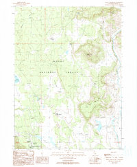 1990 Donica Mountain1990 Print · USGSThe high forest plateaus of Modoc County in the 1980s are defined by isolated peaks and vital water sources. Trace the local infrastructure of the era through Lookout Junction, Roberts Camp, and the waters of Hines Reservoir.
 - 1993 Map of Donica Mountain, 1996 Print
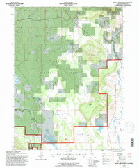 1993 Donica Mountain1996 Print · USGSNortheastern California's high forest and river country are mapped here in the early nineties, showing a landscape of timber and water management. Trace historical locations like Roberts Camp, the rail points at Lookout Junction, and the course of the Pit River.
End of results
Showing maps 1-2 of 2
Frequently asked questions
- What are the different types of historical maps available for Lookout Junction?
- What is the oldest map of Lookout Junction?
- Where can I purchase historical maps of Lookout Junction for my home or office?
- Where can I download high-res historical maps of Lookout Junction?
- Are there historical topographic maps available for Lookout Junction?
- Is there historical aerial imagery available for Lookout Junction?
- Where are historical maps of Lookout Junction sourced from?