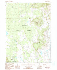
1990 Map of Donica Mountain
USGS Topo · Published 1990About this map
Modoc National Forest occupies the majority of this high-plateau landscape, characterized by isolated peaks like Donica Mountain and Splawn Mountain rising above broad flats. The terrain is marked by a complex system of water management and natural springs, including the Joiner Reservoir, Upper Roberts Reservoir, and Hines Reservoir, alongside numerous watering points such as Armentrout Spring and Loody Springs. These features, combined with the presence of Armentrout Flat, suggest a landscape shaped by seasonal grazing and remote forest operations within the public lands.
Find a feature on this map
26 named features on this map. Tap any name to fly to it.
Don’t see what you’re looking for? This feature index may not catch every label — zoom into the map to look around manually.
Map Details
Editions of this 1990 Donica Mountain Map
This is the sole edition of this map. No revisions or reprints were ever made.
Other maps of this area

1886 · Modoc Lava Bed
USGS Topo · 1:250,000

1892 · Modoc Lava-Bed
USGS Topo · 1:250,000

1954 · Alturas
USGS Topo · 1:250,000

1958 · Alturas
USGS Topo · 1:250,000

1961 · Bieber
USGS Topo · 1:62,500

1961 · Fall River Mills
USGS Topo · 1:62,500

1962 · Alturas
USGS Topo · 1:250,000

1962 · Crank Mountain
USGS Topo · 1:62,500

1962 · White Horse
USGS Topo · 1:62,500

1965 · Alturas
USGS Topo · 1:250,000