1990s Maps of McArthur, California
Explore 2 historic maps of McArthur from the 1990s. These maps offer a rare glimpse into what life looked like during the 1990s — showing old roads, neighborhoods, homes, and landmarks that have changed or disappeared over time.
Whether you're researching your family's past, planning a metal detecting trip, or studying how McArthur's landscape evolved across the 1990s, these high-resolution maps are a powerful tool for exploring the history of this region.
- Focus on a specific era: All maps on this page are from the 1990s, giving you a focused view of this time period.
- See what’s changed: Compare century-old streets, trails, and buildings to today's modern landscape using overlays and satellite layers.
- Research with precision: Use these maps for genealogy, historical research, land use analysis, or educational projects.
- View, download, or print: Maps are fully viewable online in high resolution, and can be downloaded or printed for your own records.
Start exploring McArthur's history through authentic maps from the 1990s. This is your window into the past.
McArthur, CA maps
(2)- 1990 Map of Infernal Caverns
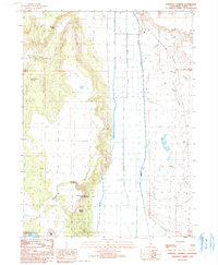 1990 Infernal Caverns1990 Print · USGSModoc County’s high desert landscape is shown here in the 1990s, where the rugged terrain meets the engineered valley of the South Fork Pit River. Historians can locate the Infernal Caverns Battleground Memorial Monument and nearby Graves from the 1867 conflict.
 - 1993 Map of Infernal Caverns, 1997 Print
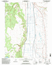 1993 Infernal Caverns1997 Print · USGSModoc County ranching and frontier history are recorded here in the early 1990s, just as the landscape's irrigation patterns were being updated. Genealogists and historians can trace the Infernal Caverns Battleground Memorial Monument and old homestead features like Wade Williams Spring.
End of results
Showing maps 1-2 of 2
Top cities near McArthur
Frequently asked questions
- What are the different types of historical maps available for McArthur?
- What is the oldest map of McArthur?
- Where can I purchase historical maps of McArthur for my home or office?
- Where can I download high-res historical maps of McArthur?
- Are there historical topographic maps available for McArthur?
- Is there historical aerial imagery available for McArthur?
- Where are historical maps of McArthur sourced from?