1990s Maps of White Horse, California
Explore 2 historic maps of White Horse from the 1990s. These maps offer a rare glimpse into what life looked like during the 1990s — showing old roads, neighborhoods, homes, and landmarks that have changed or disappeared over time.
Whether you're researching your family's past, planning a metal detecting trip, or studying how White Horse's landscape evolved across the 1990s, these high-resolution maps are a powerful tool for exploring the history of this region.
- Focus on a specific era: All maps on this page are from the 1990s, giving you a focused view of this time period.
- See what’s changed: Compare century-old streets, trails, and buildings to today's modern landscape using overlays and satellite layers.
- Research with precision: Use these maps for genealogy, historical research, land use analysis, or educational projects.
- View, download, or print: Maps are fully viewable online in high resolution, and can be downloaded or printed for your own records.
Start exploring White Horse's history through authentic maps from the 1990s. This is your window into the past.
White Horse, CA maps
(2)- 1990 Map of White Horse
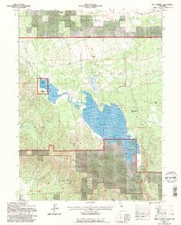
 1990 White Horse1990 Print · USGSThe Modoc County high country in the early 1990s is defined by vast reservoirs and timber history on the border of the Shasta and Modoc National Forests. Researchers can trace the legacy of logging and ranching through several Old Railroad Grades, the settlement of White Horse, and remote outposts like McArthur Cow Camp.
 - 1993 Map of White Horse, 1997 Print
 1993 White Horse1997 Print · USGSNortheastern California ranching and timber lands are captured here in the early nineties as the landscape transitioned through decades of resource use. Genealogists and historians can trace the Old Railroad Grade and find remote sites like McArthur Cow Camp and White Horse.2 unique versions available
End of results
Showing maps 1-2 of 2
Frequently asked questions
- What are the different types of historical maps available for White Horse?
- What is the oldest map of White Horse?
- Where can I purchase historical maps of White Horse for my home or office?
- Where can I download high-res historical maps of White Horse?
- Are there historical topographic maps available for White Horse?
- Is there historical aerial imagery available for White Horse?
- Where are historical maps of White Horse sourced from?