1950s Maps of Fales Hot Springs, California
Explore 3 historic maps of Fales Hot Springs from the 1950s. These maps offer a rare glimpse into what life looked like during the 1950s — showing old roads, neighborhoods, homes, and landmarks that have changed or disappeared over time.
Whether you're researching your family's past, planning a metal detecting trip, or studying how Fales Hot Springs's landscape evolved across the 1950s, these high-resolution maps are a powerful tool for exploring the history of this region.
- Focus on a specific era: All maps on this page are from the 1950s, giving you a focused view of this time period.
- See what’s changed: Compare century-old streets, trails, and buildings to today's modern landscape using overlays and satellite layers.
- Research with precision: Use these maps for genealogy, historical research, land use analysis, or educational projects.
- View, download, or print: Maps are fully viewable online in high resolution, and can be downloaded or printed for your own records.
Start exploring Fales Hot Springs's history through authentic maps from the 1950s. This is your window into the past.
Fales Hot Springs, CA maps
(3)- 1954 Map of Fales Hot Springs, 1955 Print
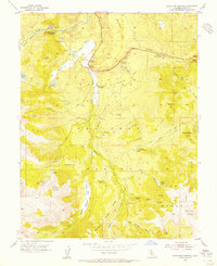 1954 Fales Hot Springs1955 Print · USGSHigh Sierra mountain life and water management are captured in the mid-1950s near the West Walker River in Mono County. Genealogists and researchers can trace seasonal mountain camps and stations like Hardy Station, Rickey Cabin, and the Little Walker Cowcamp.4 unique versions available
 - 1956 Map of Fales Hot Springs, 1960 Print
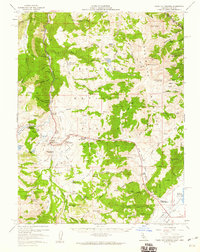 1956 Fales Hot Springs1960 Print · USGSThe high Sierra backcountry and Mono County mining districts are captured here in the mid-1950s. Genealogists and historians can trace the foundations of the regional economy through sites like Sonora Junction Hardy Station, Burcham, and the Tiger Mines.5 unique versions available
 - 1957 Map of Walker Lake
 1957 Walker Lake1957 Print · USGSThe Nevada-California borderlands in the mid-1950s show a rugged network of mining camps and river-valley towns centered around Walker Lake. Researchers can trace the Southern Pacific rail line and locate historical sites like Bodie, Sodaville, and the Leviathan Sulphur Mine.4 unique versions available
End of results
Showing maps 1-3 of 3
Top cities near Fales Hot Springs
Frequently asked questions
- What are the different types of historical maps available for Fales Hot Springs?
- What is the oldest map of Fales Hot Springs?
- Where can I purchase historical maps of Fales Hot Springs for my home or office?
- Where can I download high-res historical maps of Fales Hot Springs?
- Are there historical topographic maps available for Fales Hot Springs?
- Is there historical aerial imagery available for Fales Hot Springs?
- Where are historical maps of Fales Hot Springs sourced from?