1990s Maps of June Lake, California
Explore 2 historic maps of June Lake from the 1990s. These maps offer a rare glimpse into what life looked like during the 1990s — showing old roads, neighborhoods, homes, and landmarks that have changed or disappeared over time.
Whether you're researching your family's past, planning a metal detecting trip, or studying how June Lake's landscape evolved across the 1990s, these high-resolution maps are a powerful tool for exploring the history of this region.
- Focus on a specific era: All maps on this page are from the 1990s, giving you a focused view of this time period.
- See what’s changed: Compare century-old streets, trails, and buildings to today's modern landscape using overlays and satellite layers.
- Research with precision: Use these maps for genealogy, historical research, land use analysis, or educational projects.
- View, download, or print: Maps are fully viewable online in high resolution, and can be downloaded or printed for your own records.
Start exploring June Lake's history through authentic maps from the 1990s. This is your window into the past.
June Lake, CA maps
(2)- 1992 Map of June Lake, 1995 Print
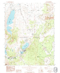 1992 June Lake1995 Print · USGSThe Eastern Sierra highlands are captured here in the early nineties, showcasing the mountain lakes and volcanic terrain of the Mono Basin. You can trace the development of the June Mtn Ski Area and locate recreation sites near Gull Lake and Obsidian Dome.
 - 1994 Map of June Lake, 1997 Print
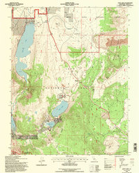 1994 June Lake1997 Print · USGSThe eastern Sierra Nevada loop comes to life in the mid-1990s, centered on the glacial lakes and volcanic formations of the Mono Basin. Trace local landmarks like the PENSTOCK TRAMWAY, the shores of Silver Lake, and the massive Obsidian Dome in this detailed U.S. Forest Service revision.
End of results
Showing maps 1-2 of 2
Top cities near June Lake
Frequently asked questions
- What are the different types of historical maps available for June Lake?
- What is the oldest map of June Lake?
- Where can I purchase historical maps of June Lake for my home or office?
- Where can I download high-res historical maps of June Lake?
- Are there historical topographic maps available for June Lake?
- Is there historical aerial imagery available for June Lake?
- Where are historical maps of June Lake sourced from?