2020s Maps of Carmel Highlands, California
Explore 1 historic maps of Carmel Highlands from the 2020s. These maps offer a rare glimpse into what life looked like during the 2020s — showing old roads, neighborhoods, homes, and landmarks that have changed or disappeared over time.
Whether you're researching your family's past, planning a metal detecting trip, or studying how Carmel Highlands's landscape evolved across the 2020s, these high-resolution maps are a powerful tool for exploring the history of this region.
- Focus on a specific era: All maps on this page are from the 2020s, giving you a focused view of this time period.
- See what’s changed: Compare century-old streets, trails, and buildings to today's modern landscape using overlays and satellite layers.
- Research with precision: Use these maps for genealogy, historical research, land use analysis, or educational projects.
- View, download, or print: Maps are fully viewable online in high resolution, and can be downloaded or printed for your own records.
Start exploring Carmel Highlands's history through authentic maps from the 2020s. This is your window into the past.
Carmel Highlands, CA maps
(1)- 2021 Map of Monterey, 2021 Print
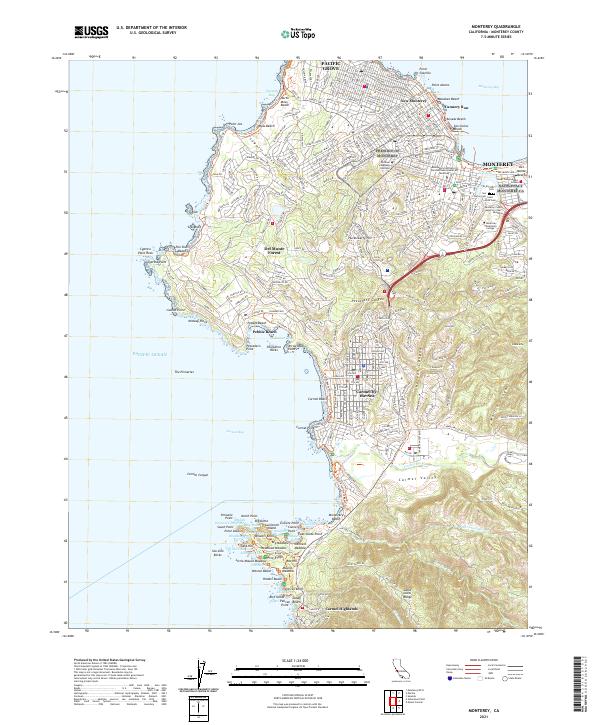 2021 Monterey2021 Print · USGSMonterey and the Monterey Peninsula are shown here in the early twenty-first century, featuring the famous shoreline from Pacific Grove to Carmel. Researchers can trace historic sites like Cannery Row, locate family records at El-Encinal Cem, or study the grounds of the Naval Postgraduate School.
End of results
Showing maps 1-1 of 1
Top cities near Carmel Highlands
- Monterey historical maps
- Marina historical maps
- Pacific Grove historical maps
- Carmel-by-the-Sea historical maps
- Del Rey Oaks historical maps
- Sand City historical maps
Frequently asked questions
- What are the different types of historical maps available for Carmel Highlands?
- What is the oldest map of Carmel Highlands?
- Where can I purchase historical maps of Carmel Highlands for my home or office?
- Where can I download high-res historical maps of Carmel Highlands?
- Are there historical topographic maps available for Carmel Highlands?
- Is there historical aerial imagery available for Carmel Highlands?
- Where are historical maps of Carmel Highlands sourced from?