1940s Maps of Lonoak, California
Explore 3 historic maps of Lonoak from the 1940s. These maps offer a rare glimpse into what life looked like during the 1940s — showing old roads, neighborhoods, homes, and landmarks that have changed or disappeared over time.
Whether you're researching your family's past, planning a metal detecting trip, or studying how Lonoak's landscape evolved across the 1940s, these high-resolution maps are a powerful tool for exploring the history of this region.
- Focus on a specific era: All maps on this page are from the 1940s, giving you a focused view of this time period.
- See what’s changed: Compare century-old streets, trails, and buildings to today's modern landscape using overlays and satellite layers.
- Research with precision: Use these maps for genealogy, historical research, land use analysis, or educational projects.
- View, download, or print: Maps are fully viewable online in high resolution, and can be downloaded or printed for your own records.
Start exploring Lonoak's history through authentic maps from the 1940s. This is your window into the past.
Lonoak, CA maps
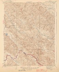
(3)- 1943 Map of Hernandez Valley, 1948 Print
 1943 Hernandez Valley1948 Print · USGSThe coastal ranges of Central California appear here in the early 1940s, mapping a landscape of isolated cattle ranches and remote canyons. Researchers can trace family sites like Garcia Ranch, the Bitterwater Tully Sch, and the Fire Flex Mine.
 - 1944 Map of Hernandez Valley
 1944 Hernandez Valley1944 Print · USGSThe remote ranching country of San Benito and Monterey counties is captured here just before the mid-forties. Genealogists and historians can trace family locations like Low Smith Ranch, find rural schools such as Hernandez Sch, and locate the Fire Flex Mine.2 unique versions available
 - 1948 Map of Santa Cruz
 1948 Santa Cruz1948 Print · USGSThe Central Coast and San Joaquin Valley meet in this mid-century look at the region's agricultural and military geography. Genealogists and historians can trace the paths of El Camino Real, locate family farms near Hollister, or study the footprint of the Fort Ord Military Reservation.2 unique versions available
End of results
Showing maps 1-3 of 3
Frequently asked questions
- What are the different types of historical maps available for Lonoak?
- What is the oldest map of Lonoak?
- Where can I purchase historical maps of Lonoak for my home or office?
- Where can I download high-res historical maps of Lonoak?
- Are there historical topographic maps available for Lonoak?
- Is there historical aerial imagery available for Lonoak?
- Where are historical maps of Lonoak sourced from?