
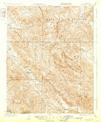
1943 Map of Hernandez Valley
USGS Topo · Published 1948About this map
Bitterwater Valley and the surrounding coastal ranges of San Benito County and Monterey County reveal a landscape defined by isolated ranching outposts and rugged canyons. The area is characterized by family-held land such as the Lew Smith Ranch and De Alvarez Ranch, while local education is anchored by the Bitterwater Tully Sch and Hernandez Sch. This 1941 survey captures the region just before mid-century modernization, where industry is limited to the Fire Flex Mine and an Oil Pumping Sta near the southern boundary.
Find a feature on this map
65 named features on this map. Tap any name to fly to it.
Don’t see what you’re looking for? This feature index may not catch every label — zoom into the map to look around manually.
Map Details
Editions of this 1943 Hernandez Valley Map
This is the sole edition of this map. No revisions or reprints were ever made.
Other maps of this area

1913 · Panoche
USGS Topo · 1:125,000

1915 · Priest Valley
USGS Topo · 1:125,000

1919 · King City
USGS Topo · 1:62,500

1919 · San Benito
USGS Topo · 1:62,500

1921 · Metz
USGS Topo · 1:62,500
1931 · San Benito
USGS Topo · 1:62,500

1939 · King City
USGS Topo · 1:62,500

1940 · Metz
USGS Topo · 1:62,500
1940 · San Benito
USGS Topo · 1:62,500

1941 · Priest Valley
USGS Topo · 1:62,500