
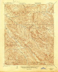
1931 Map of San Benito
USGS Topo · Published 1931About this map
The San Benito River carves a deep path through this portion of the Call Mountains Range and Gabilan Range during the early twentieth century. This landscape is defined by its isolation and the rugged canyon networks of Bickmore Canyon and Pinnacles Valley. The map shows the northern portion of Pinnacles Nat Mon, established years prior to this 1917 survey, revealing the early protected boundaries of this unique geological area. Settlement is sparse, represented by family ranching operations like Los Muertos Ranch and Butts Ranch. Education was localized in small rural outposts, evidenced by the distribution of the Cottonwood School and Antelope School. The industrial presence is limited to the Bradford Mine, reached via the New Idria Road, which served as a vital transit link through the difficult terrain of Chemise Ridge.
Find a feature on this map
38 named features on this map. Tap any name to fly to it.
Don’t see what you’re looking for? This feature index may not catch every label — zoom into the map to look around manually.
Map Details
Editions of this 1931 San Benito Map
2 editions found
Other maps of this area

1913 · Panoche
USGS Topo · 1:125,000

1915 · Soledad
USGS Topo · 1:62,500

1915 · Priest Valley
USGS Topo · 1:125,000

1919 · San Benito
USGS Topo · 1:62,500

1919 · Hollister
USGS Topo · 1:48,000

1921 · Gonzales
USGS Topo · 1:62,500

1921 · Metz
USGS Topo · 1:62,500

1921 · Hollister
USGS Topo · 1:62,500

1922 · Quien Sabe
USGS Topo · 1:62,500

1923 · Hollister
USGS Topo · 1:62,500