
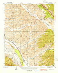
1941 Map of Priest Valley
USGS Topo · Published 1941About this map
Priest Valley and the surrounding high country of the Diablo Range are defined by a complex network of seasonal creeks and steep ridges as they appeared in the early 1940s. This survey, conducted by W. R. Chenoweth and L. O. Newsome, documents the convergence of Monterey, San Benito, and Fresno counties. The map captures the remote settlement of San Lorenzo (Randall) and the isolated Priest Valley Sch, reflecting a ranching and mining economy reliant on rugged thoroughfares like the Peachtree Road.
Find a feature on this map
96 named features on this map. Tap any name to fly to it.
Don’t see what you’re looking for? This feature index may not catch every label — zoom into the map to look around manually.
Map Details
Editions of this 1941 Priest Valley Map
This is the sole edition of this map. No revisions or reprints were ever made.
Other maps of this area

1912 · Coalinga
USGS Topo · 1:125,000

1914 · Cholame
USGS Topo · 1:125,000

1915 · Priest Valley
USGS Topo · 1:125,000

1915 · Cholame
USGS Topo · 1:125,000

1917 · Cholame
USGS Topo · 1:125,000

1919 · San Miguel
USGS Topo · 1:62,500

1919 · Bradley
USGS Topo · 1:62,500
1941 · San Ardo
USGS Topo · 1:62,500
1941 · Bradley
USGS Topo · 1:62,500

1942 · Parkfield
USGS Topo · 1:24,000