1960s Maps of Pine Canyon, California
Explore 2 historic maps of Pine Canyon from the 1960s. These maps offer a rare glimpse into what life looked like during the 1960s — showing old roads, neighborhoods, homes, and landmarks that have changed or disappeared over time.
Whether you're researching your family's past, planning a metal detecting trip, or studying how Pine Canyon's landscape evolved across the 1960s, these high-resolution maps are a powerful tool for exploring the history of this region.
- Focus on a specific era: All maps on this page are from the 1960s, giving you a focused view of this time period.
- See what’s changed: Compare century-old streets, trails, and buildings to today's modern landscape using overlays and satellite layers.
- Research with precision: Use these maps for genealogy, historical research, land use analysis, or educational projects.
- View, download, or print: Maps are fully viewable online in high resolution, and can be downloaded or printed for your own records.
Start exploring Pine Canyon's history through authentic maps from the 1960s. This is your window into the past.
Pine Canyon, CA maps
(2)- 1961 Map of King City, 1968 Print
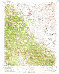 1961 King City1968 Print · USGSThe Salinas River valley in the early 1960s shows a landscape of rail-connected agriculture and expanding military installations. Genealogists and historians can trace the Southern Pacific line through King City down to San Lucas, or locate family landmarks in Quinado Canyon and the Hunter Liggett Military Reservation.
 - 1965 Map of Santa Cruz, 1968 Print
 1965 Santa Cruz1968 Print · USGSThe Central Coast and San Joaquin Valley meet here during the mid-sixties, capturing the growth of agricultural and coastal hubs. Trace the historic Southern Pacific RR lines and locate sites like the Presidio of Monterey or Pinnacles National Monument.
End of results
Showing maps 1-2 of 2
Top cities near Pine Canyon
Frequently asked questions
- What are the different types of historical maps available for Pine Canyon?
- What is the oldest map of Pine Canyon?
- Where can I purchase historical maps of Pine Canyon for my home or office?
- Where can I download high-res historical maps of Pine Canyon?
- Are there historical topographic maps available for Pine Canyon?
- Is there historical aerial imagery available for Pine Canyon?
- Where are historical maps of Pine Canyon sourced from?