1980s Maps of Seaside, California
Explore 2 historic maps of Seaside from the 1980s. These maps offer a rare glimpse into what life looked like during the 1980s — showing old roads, neighborhoods, homes, and landmarks that have changed or disappeared over time.
Whether you're researching your family's past, planning a metal detecting trip, or studying how Seaside's landscape evolved across the 1980s, these high-resolution maps are a powerful tool for exploring the history of this region.
- Focus on a specific era: All maps on this page are from the 1980s, giving you a focused view of this time period.
- See what’s changed: Compare century-old streets, trails, and buildings to today's modern landscape using overlays and satellite layers.
- Research with precision: Use these maps for genealogy, historical research, land use analysis, or educational projects.
- View, download, or print: Maps are fully viewable online in high resolution, and can be downloaded or printed for your own records.
Start exploring Seaside's history through authentic maps from the 1980s. This is your window into the past.
Seaside, CA maps
(2)- 1983 Map of Monterey, 1984 Print
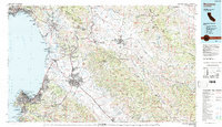 1983 Monterey1984 Print · USGSCoastal Monterey and the Salinas Valley appear in the early eighties as a hub of military activity and deep-rooted agriculture. Researchers can trace historic land grant boundaries like Rancho Buena Vista or locate sites like Mission San Juan Bautista and Spreckels.2 unique versions available
 - 1983 Map of Seaside, 1985 Print
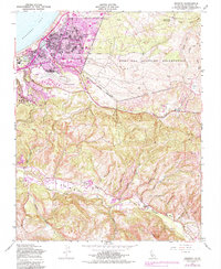 1983 Seaside1985 Print · USGSThe Monterey coastline was undergoing rapid suburban growth in the early eighties as urban areas expanded toward the surrounding hills. Researchers can trace local development through dozens of neighborhood landmarks, from the U S Navy Post Graduate Sch to the Laguna Seca Recreation Area.
End of results
Showing maps 1-2 of 2
Top cities near Seaside
- Salinas historical maps
- Monterey historical maps
- Marina historical maps
- Prunedale historical maps
- Pacific Grove historical maps
- Carmel-by-the-Sea historical maps
See more
Top neighborhoods of Seaside
Frequently asked questions
- What are the different types of historical maps available for Seaside?
- What is the oldest map of Seaside?
- Where can I purchase historical maps of Seaside for my home or office?
- Where can I download high-res historical maps of Seaside?
- Are there historical topographic maps available for Seaside?
- Is there historical aerial imagery available for Seaside?
- Where are historical maps of Seaside sourced from?