1950s Maps of Yountville, California
Explore 4 historic maps of Yountville from the 1950s. These maps offer a rare glimpse into what life looked like during the 1950s — showing old roads, neighborhoods, homes, and landmarks that have changed or disappeared over time.
Whether you're researching your family's past, planning a metal detecting trip, or studying how Yountville's landscape evolved across the 1950s, these high-resolution maps are a powerful tool for exploring the history of this region.
- Focus on a specific era: All maps on this page are from the 1950s, giving you a focused view of this time period.
- See what’s changed: Compare century-old streets, trails, and buildings to today's modern landscape using overlays and satellite layers.
- Research with precision: Use these maps for genealogy, historical research, land use analysis, or educational projects.
- View, download, or print: Maps are fully viewable online in high resolution, and can be downloaded or printed for your own records.
Start exploring Yountville's history through authentic maps from the 1950s. This is your window into the past.
Yountville, CA maps
(4)- 1951 Map of Yountville, 1952 Print
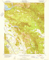 1951 Yountville1952 Print · USGSThe Napa Valley floor and its eastern ridges appear here in the early 1950s, showing a landscape of state-run farms and mountain ranches. Researchers can trace the original Silverado Trail, the grounds of the State Veterans Home, and landmarks like Stags Leap.6 unique versions available
 - 1951 Map of Rutherford, 1952 Print
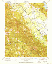 1951 Rutherford1952 Print · USGSNapa Valley during the early fifties reveals a landscape of rural viticulture and mountain mining operations. Local researchers can trace the rail corridor through Rutherford and Oakville or locate historical sites like La Joya Quicksilver Mine and Enterprise Sch.6 unique versions available
 - 1951 Map of Sonoma, 1958 Print
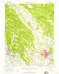 1951 Sonoma1958 Print · USGSWine country was already maturing in the mid-twentieth century as rail lines and early wineries shaped the valley landscape. Researchers can trace the legacy of established vineyards at Thomann Winery and Buena Vista or locate old burial grounds like Yountville Cem.3 unique versions available
 - 1958 Map of Santa Rosa, 1968 Print
 1958 Santa Rosa1968 Print · USGSThe North Bay and Wine Country are captured in the mid-twentieth century as the region balanced its agricultural roots with a growing military and recreational footprint. Researchers can trace the Northwestern Pacific RR through the Russian River valley or locate landmarks like the Petaluma Adobe Historical Monument and The Geysers Resort.3 unique versions available
End of results
Showing maps 1-4 of 4
Top cities near Yountville
- Santa Rosa historical maps
- Vallejo historical maps
- Fairfield historical maps
- Napa historical maps
- Petaluma historical maps
- American Canyon historical maps
See more
Frequently asked questions
- What are the different types of historical maps available for Yountville?
- What is the oldest map of Yountville?
- Where can I purchase historical maps of Yountville for my home or office?
- Where can I download high-res historical maps of Yountville?
- Are there historical topographic maps available for Yountville?
- Is there historical aerial imagery available for Yountville?
- Where are historical maps of Yountville sourced from?