2020s Maps of Nevada County, California
Explore 32 historic maps of Nevada County from the 2020s. These maps offer a rare glimpse into what life looked like during the 2020s — showing old roads, neighborhoods, homes, and landmarks that have changed or disappeared over time.
Whether you're researching your family's past, planning a metal detecting trip, or studying how Nevada County's landscape evolved across the 2020s, these high-resolution maps are a powerful tool for exploring the history of this region.
- Focus on a specific era: All maps on this page are from the 2020s, giving you a focused view of this time period.
- See what’s changed: Compare century-old streets, trails, and buildings to today's modern landscape using overlays and satellite layers.
- Research with precision: Use these maps for genealogy, historical research, land use analysis, or educational projects.
- View, download, or print: Maps are fully viewable online in high resolution, and can be downloaded or printed for your own records.
Start exploring Nevada County's history through authentic maps from the 2020s. This is your window into the past.
Nevada County, CA maps
(32)- 2021 Map of Hobart Mills, 2021 Print
 2021 Hobart Mills2021 Print · USGSThe high timber country of the Sierra Nevada comes alive in this 2021 survey of the lands between Sierra and Nevada counties. Researchers can trace the historic Commemorative Overland Emigrant Trail and locate sites like Hobart Mills and Woodchoppers Spring.
 - 2021 Map of Oregon House, 2021 Print
 2021 Oregon House2021 Print · USGSThe foothills of Yuba County are documented here during a period of modern water management and rural settlement. Researchers can trace the layout of Oregon House, the infrastructure of Merle Collins Reservoir, and local landmarks like the Old Aerodrome.
 - 2021 Map of Smartsville, 2021 Print
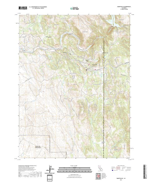 2021 Smartsville2021 Print · USGSThe Gold Country foothills between Yuba and Nevada counties appear in detail during the early 2020s. Researchers can locate historic cemetery sites like Timbuctoo Cem and trace the paths of old hydraulic mining settlements at Sucker Flat and Mooney Flat.
 - 2021 Map of Haypress Valley, 2021 Print
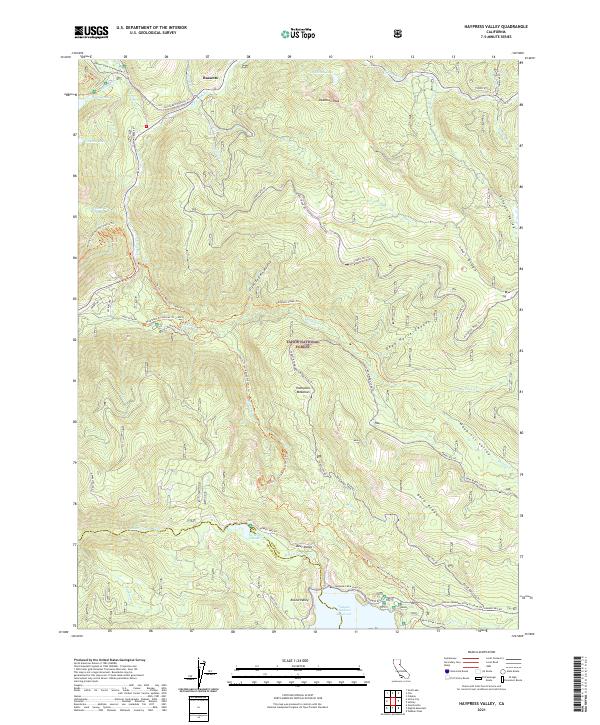 2021 Haypress Valley2021 Print · USGSThe High Sierra backcountry near the Sierra and Nevada County line is shown here in the 2020s, dominated by the Tahoe National Forest. Researchers can trace the historic Henness Pass Road and locate remote landmarks like Deadman Peak and Milton Reservoir.
 - 2021 Map of Martis Peak, 2021 Print
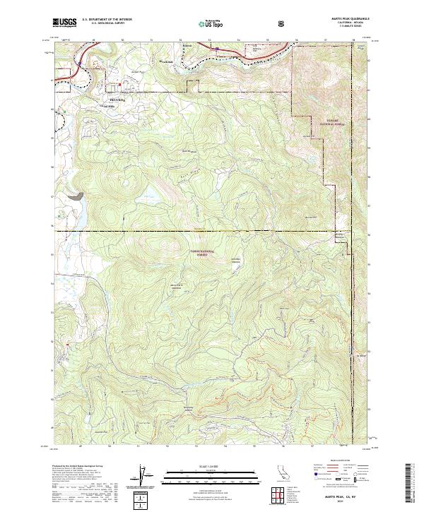 2021 Martis Peak2021 Print · USGSThe high Sierra peaks and valley meadows north of Lake Tahoe are captured here in the early twenty-first century. Local researchers can trace the modern expansion of Truckee alongside legacy landmarks like Union Mills, Hirschdale, and Brockway Summit.
 - 2021 Map of Independence Lake, 2021 Print
 2021 Independence Lake2021 Print · USGSThe High Sierra backcountry near the Sierra and Nevada County line is presented here in great detail during the early 2020s. Hikers and historians can trace the Pacific Crest National Scenic Trl, the historic Old Henness Pass Trl, and family-named landmarks like Meathouse Meadow or Mt Lola.
 - 2021 Map of Sierra City, 2021 Print
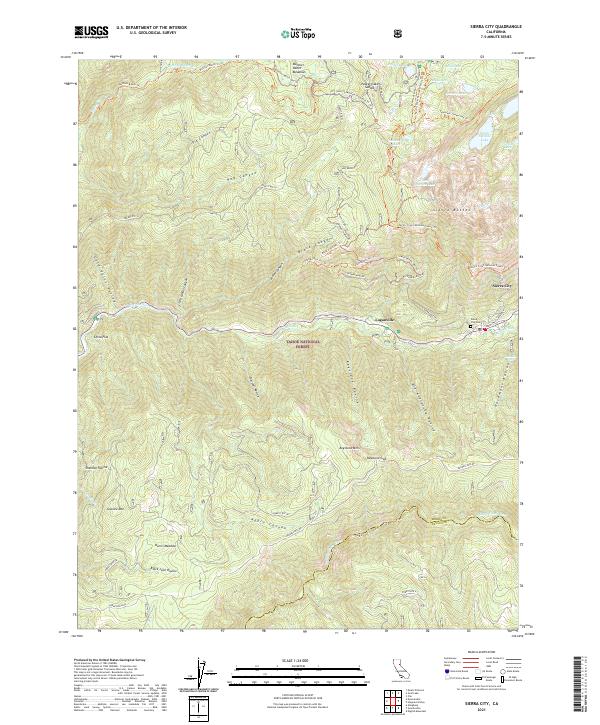 2021 Sierra City2021 Print · USGSThe steep Sierra Nevada peaks of the Tahoe National Forest define this region near the century's end. Researchers can trace historic routes like Henness Pass Rd or locate family sites at Sierra City Cem and Harris Meadow.
 - 2021 Map of Pike, 2021 Print
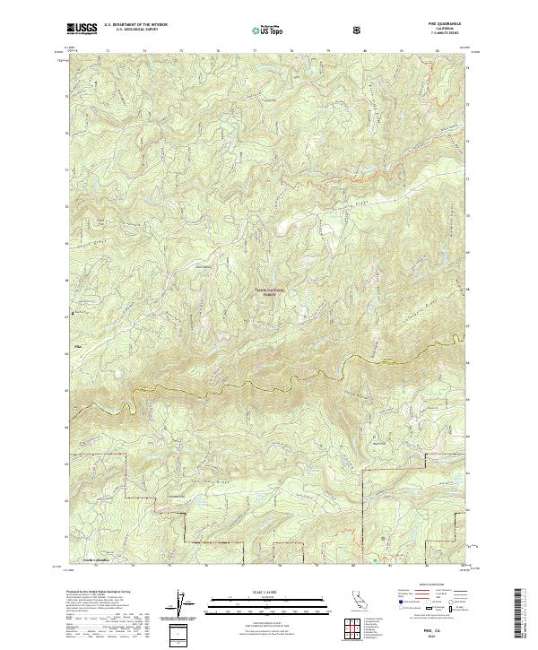 2021 Pike2021 Print · USGSThe Sierra Nevada foothills come into sharp focus in this recent survey of the rugged divide between the Yuba and its tributaries. Researchers can trace the layout of Pike and North Columbia, or locate historic sites like the Pike City Cem and the Black Sands Mine.
 - 2021 Map of Graniteville, 2021 Print
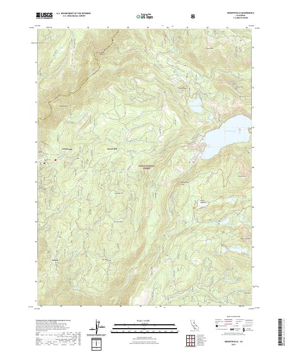 2021 Graniteville2021 Print · USGSThe high Sierra terrain of Nevada and Sierra counties is documented here in the early twenty-first century. Genealogists and historians can locate Graniteville Cem and trace the paths to historic sites like Marsh Mill and the settlement of Gaston.
 - 2021 Map of Lake Combie, 2021 Print
 2021 Lake Combie2021 Print · USGSThe foothills of the Sierra Nevada are shown here as a landscape of modern residential estates and enduring water infrastructure. Researchers can trace historic water routes like the Stockton Hill Ditch and Combie Ophir Canal alongside developments such as Meadow Vista and Lake of the Pines.
 - 2021 Map of Webber Peak, 2021 Print
 2021 Webber Peak2021 Print · USGSThe high Sierra crest at the Nevada and Sierra County border comes alive in this contemporary survey of the Tahoe National Forest. Genealogists and hikers can trace the historic Henness Pass Road and locate remote alpine landmarks like Webber Lake or the shores of Fordyce Lake.
 - 2021 Map of Rough And Ready, 2021 Print
 2021 Rough And Ready2021 Print · USGSNevada County's historic gold country landscape appears here in the early twenty-first century, balancing modern residential growth with its deep mining roots. Researchers can locate several burial grounds including Rough and Ready Cem and trace historic water systems like the Tarr Ditch.
 - 2021 Map of Soda Springs, 2021 Print
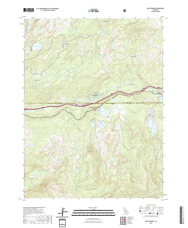 2021 Soda Springs2021 Print · USGSThe high Sierra Nevada landscape near the Nevada and Placer county line is captured here in the early 2020s. Hikers and historians can trace the paths around Soda Springs, the shores of Loch Leven Lakes, and the rugged climb toward Devils Peak.
 - 2021 Map of Colfax, 2021 Print
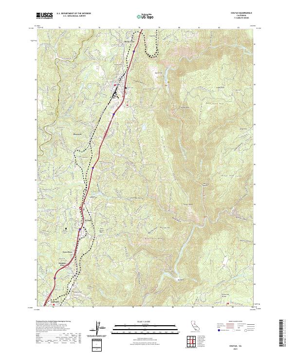 2021 Colfax2021 Print · USGSPlacer County's rail-line settlements and steep canyon topography are captured here in the contemporary era. Genealogists and hikers can trace old routes near Colfax, the Weimar Sanitorium Cem, and the path of the Stevens Trl along the river.
 - 2022 Map of Cisco Grove, 2022 Print
 2022 Cisco Grove2022 Print · USGSCisco and the high Sierra passes of Placer and Nevada counties are captured here in the early twenty-first century. Researchers can trace historic mountain routes and water systems near Big Bend, Lake Valley Reservoir, and the fire lookout at Signal Peak.
 - 2022 Map of Blue Canyon, 2022 Print
 2022 Blue Canyon2022 Print · USGSThe high Sierra ridges of Placer and Nevada Counties are captured here in modern detail, showing the historic crossing at Emigrant Gap. Researchers can trace the legacy of gold-era water systems and mountain settlements from Omega Cem to Blue Canyon.
 - 2022 Map of Truckee, 2022 Print
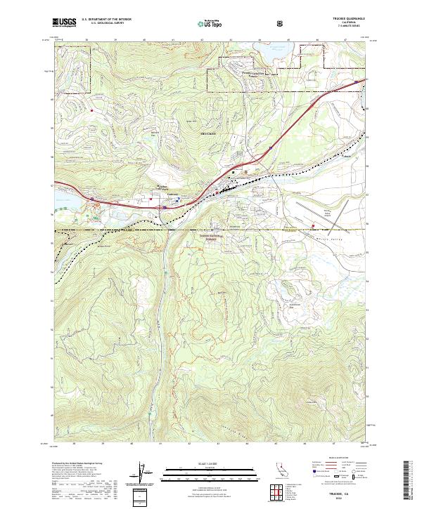 2022 Truckee2022 Print · USGSThe Sierra Nevada foothills near the Nevada and Placer county line are shown here in modern detail, where alpine peaks meet a growing mountain community. Genealogists and historians can trace local sites like the Old Truckee Catholic Cemetery, the Truckee Courthouse, and the waters of Donner Lake.
 - 2022 Map of English Mountain, 2022 Print
 2022 English Mountain2022 Print · USGSHigh in the Sierra Nevada during the early twenty-first century, this area reveals a landscape of alpine lakes and old mountain outposts. Researchers can locate the site of Baltimore Town, the Meadow Lake Cem, and traces of the Fordyce Jeep Trl.
 - 2022 Map of Dutch Flat, 2022 Print
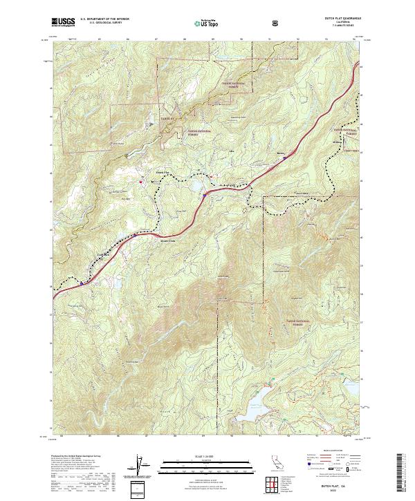 2022 Dutch Flat2022 Print · USGSThe Sierra Nevada foothills near Dutch Flat and Gold Run come alive in this contemporary survey of Placer County. Genealogists and historians can trace old community sites like Towle and Midas or locate the historic Dutch Flat Cemetery.
 - 2022 Map of Alleghany, 2022 Print
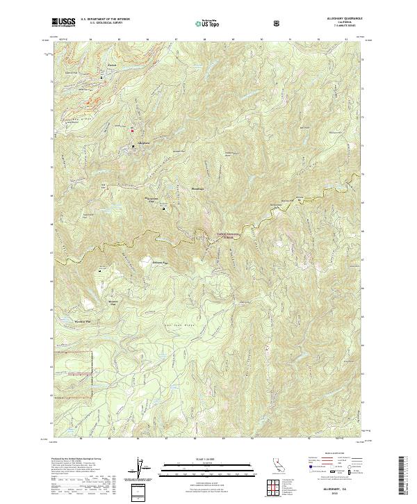 2022 Alleghany2022 Print · USGSSierra and Nevada counties were shaped by the search for gold and the timber industry during this era of deep-canyon development. Researchers can trace historic hillside sites and mountain cemeteries like the Alleghany Cem, Plumbago, and Moores Flat Cem.
 - 2022 Map of Norden, 2022 Print
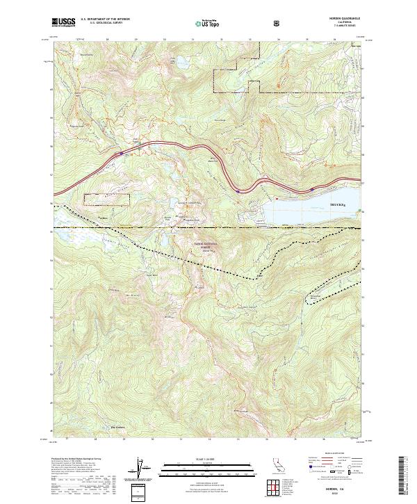 2022 Norden2022 Print · USGSThe high Sierra Nevada at the summit of the transcontinental passage shows a landscape of deep granite canyons and historic mountain crossings. You can trace the path of the Old Donner Summit Rd as it winds past McGlashan Point and the alpine waters of Lake Angela.
 - 2022 Map of North Bloomfield, 2022 Print
 2022 North Bloomfield2022 Print · USGSThe historic gold-mining corridor of the San Juan Ridge is captured here in the early twenty-first century. Genealogists and researchers can trace local landmarks like North Bloomfield Cem, the remote settlement of Missouri Bar, and the waters of Scotts Flat Reservoir.
 - 2022 Map of Boca, 2022 Print
 2022 Boca2022 Print · USGSThis high-country corridor along the California-Nevada border was surveyed in the early 2020s, showing the intersection of major reservoirs and mountain passes. Researchers can trace the river-bound settlements of Boca, Floriston, and Mystic alongside the summits of the Verdi Range.
 - 2022 Map of Washington, 2022 Print
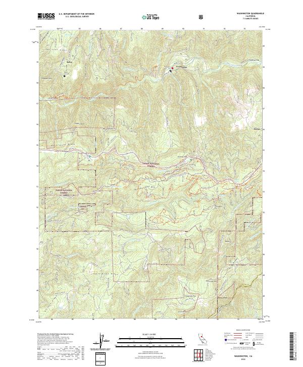 2022 Washington2022 Print · USGSThe northern Sierra Nevada's rugged mining country is captured here during the early twenty-first century. Researchers can trace historic mountain settlements like Washington and Relief, locate the Relief Hill Cem, or follow the industrial path of the Yuba Canal.
 - 2022 Map of Chicago Park, 2022 Print
 2022 Chicago Park2022 Print · USGSThe Sierra foothills around Nevada County are documented here in the early twenty-first century, showing a landscape defined by historic gold-rush settlements and water engineering. Researchers can trace the path of the U P R R through Secret Town or locate the Saint Paul Lutheran Cem near Bear River Pines.
Showing maps 1-25 of 32
Top cities of Nevada County
- Truckee historical maps
- Grass Valley historical maps
- Nevada City historical maps
- Rough and Ready historical maps
- Washington historical maps
- Kingvale historical maps
See more
Frequently asked questions
- What are the different types of historical maps available for Nevada County?
- What is the oldest map of Nevada County?
- Where can I purchase historical maps of Nevada County for my home or office?
- Where can I download high-res historical maps of Nevada County?
- Are there historical topographic maps available for Nevada County?
- Is there historical aerial imagery available for Nevada County?
- Where are historical maps of Nevada County sourced from?