1900s (20th Century) Maps of Alta Sierra Ranches, California
Explore 8 historic maps of Alta Sierra Ranches from the 1900s (20th Century). These maps offer a rare glimpse into what life looked like during the 1900s — showing old roads, neighborhoods, homes, and landmarks that have changed or disappeared over time.
Whether you're researching your family's past, planning a metal detecting trip, or studying how Alta Sierra Ranches's landscape evolved across the 1900s, these high-resolution maps are a powerful tool for exploring the history of this region.
- Focus on a specific era: All maps on this page are from the 1900s, giving you a focused view of this time period.
- See what’s changed: Compare century-old streets, trails, and buildings to today's modern landscape using overlays and satellite layers.
- Research with precision: Use these maps for genealogy, historical research, land use analysis, or educational projects.
- View, download, or print: Maps are fully viewable online in high resolution, and can be downloaded or printed for your own records.
Start exploring Alta Sierra Ranches's history through authentic maps from the 1900s. This is your window into the past.
Alta Sierra Ranches, CA maps
(8)- 1949 Map of Grass Valley, 1953 Print
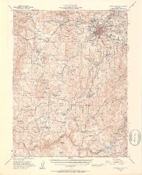 1949 Grass Valley1953 Print · USGSGold mining operations dominate the landscape around the Sierra foothills just after the war. Local researchers can trace the extent of the Empire Mine, find remote outposts like Anthony House, or locate rural schools such as Limekiln Sch and Forest Springs Sch.5 unique versions available
 - 1949 Map of Lake Combie, 1960 Print
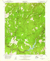 1949 Lake Combie1960 Print · USGSNevada and Placer Counties are captured here just after the war, showing the emergence of Lake Combie along the Bear River. Genealogists and historians can trace the Probable Route of Donner Party alongside local landmarks like the Stockton Hill Mine and Limekiln Sch.4 unique versions available
 - 1950 Map of Lake Combie
 1950 Lake Combie1950 Print · USGSThe Nevada and Placer County line comes alive in the late 1940s, showing a landscape defined by water engineering and pioneer history. You can trace the Probable Route of Donner Party near Lake Combie or locate the Stockton Hill Mine and Limekiln Sch.2 unique versions available
 - 1958 Map of Chico, 1962 Print
 1958 Chico1962 Print · USGSMid-century Northern California comes to life across the Central Valley and high Sierras as the postwar economy transformed the landscape. Trace the rail lines of the Southern Pacific RR, locate family roots near Chico Cem, or explore the early layout of Paradise and Beale Air Force Base.4 unique versions available
 - 1960 Map of Chico
 1960 Chico1960 Print · USGSThe Northern California high country and Sacramento Valley meet in this 1960s-era landscape of mining towns and river settlements. Trace the rail-and-water economy of the gold country through the Empire Mine, Beale Air Force Base, and the Western Pacific Railroad.
 - 1993 Map of Yuba City, 1994 Print
 1993 Yuba City1994 Print · USGSThe Sacramento Valley and Sierra Nevada foothills meet in the 1990s, where agricultural bypasses and river networks surround the iconic Sutter Buttes. Researchers can trace the rail corridors of the Southern Pacific and Western Pacific through hubs like Marysville and Gridley.
 - 1995 Map of Lake Combie
 1995 Lake Combie1995 Print · USGSThe Sierra Nevada foothills emerge in the mid-nineties as a blend of suburban growth and historic water systems. Genealogists and historians can trace the Overland Emigrant Road and locate the Stockton Hill Mine near Lake Combie.
 - 1998 Map of Lake Combie, 2002 Print
 1998 Lake Combie2002 Print · USGSNorthern California hill country at the turn of the millennium shows a fascinating mix of pioneer trails and modern water management. Trace the historic Overland Emigrant Road past the Stockton Hill Mine or the shores of Lake of the Pines.
End of results
Showing maps 1-8 of 8
Top cities near Alta Sierra Ranches
- Lincoln historical maps
- Grass Valley historical maps
- Auburn historical maps
- Meadow Vista historical maps
- Nevada City historical maps
- Colfax historical maps
See more
Frequently asked questions
- What are the different types of historical maps available for Alta Sierra Ranches?
- What is the oldest map of Alta Sierra Ranches?
- Where can I purchase historical maps of Alta Sierra Ranches for my home or office?
- Where can I download high-res historical maps of Alta Sierra Ranches?
- Are there historical topographic maps available for Alta Sierra Ranches?
- Is there historical aerial imagery available for Alta Sierra Ranches?
- Where are historical maps of Alta Sierra Ranches sourced from?