1940s Maps of Birchville, California
Explore 2 historic maps of Birchville from the 1940s. These maps offer a rare glimpse into what life looked like during the 1940s — showing old roads, neighborhoods, homes, and landmarks that have changed or disappeared over time.
Whether you're researching your family's past, planning a metal detecting trip, or studying how Birchville's landscape evolved across the 1940s, these high-resolution maps are a powerful tool for exploring the history of this region.
- Focus on a specific era: All maps on this page are from the 1940s, giving you a focused view of this time period.
- See what’s changed: Compare century-old streets, trails, and buildings to today's modern landscape using overlays and satellite layers.
- Research with precision: Use these maps for genealogy, historical research, land use analysis, or educational projects.
- View, download, or print: Maps are fully viewable online in high resolution, and can be downloaded or printed for your own records.
Start exploring Birchville's history through authentic maps from the 1940s. This is your window into the past.
Birchville, CA maps
(2)- 1948 Map of Nevada City, 1953 Print
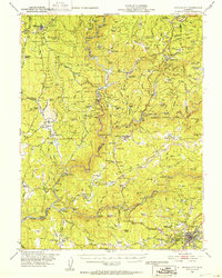 1948 Nevada City1953 Print · USGSNevada City and the Yuba River canyons are captured here in the late 1940s, just as modern reservoirs began to reshape the old gold country. Genealogists and historians can trace family-named sites like Godfrey Ranch (Pike PO), Pleasant Valley Sch, and the Nevada City Rancheria.4 unique versions available
 - 1948 Map of French Corral, 1961 Print
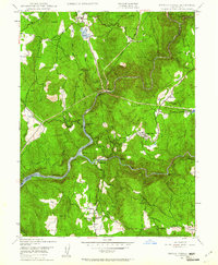 1948 French Corral1961 Print · USGSThe Gold Country of Yuba and Nevada Counties comes into focus just after the war as hydroelectric power began to reshape the river canyons. Researchers can locate the San Juan Mine, the village of French Corral, and the Pleasant Valley Sch.4 unique versions available
End of results
Showing maps 1-2 of 2
Top cities near Birchville
- Grass Valley historical maps
- Nevada City historical maps
- Colfax historical maps
- Rough and Ready historical maps
Frequently asked questions
- What are the different types of historical maps available for Birchville?
- What is the oldest map of Birchville?
- Where can I purchase historical maps of Birchville for my home or office?
- Where can I download high-res historical maps of Birchville?
- Are there historical topographic maps available for Birchville?
- Is there historical aerial imagery available for Birchville?
- Where are historical maps of Birchville sourced from?