Old Maps of Brea, California for Genealogy
Trace your family roots with 34 historic maps of Brea. These high-res maps reveal old neighborhoods, homesites, landmarks, and streets — helping you uncover where your ancestors lived and how the area evolved over time.
- Explore historic neighborhoods: Identify where your relatives may have lived in the 1800s or 1900s.
- Compare maps over time: Trace the changes in streets, buildings, and landmarks for multi-generational research.
- Perfect for genealogy & ancestry research: Used by family historians and researchers to map out lineage and migration.
These maps are an incredible resource for exploring your personal connection to Brea's past.
Brea, CA maps
(34)- 1896 Map of Anaheim
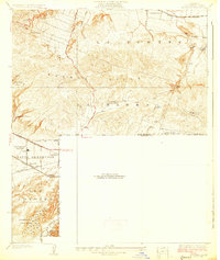
 1896 Anaheim1896 Print · USGSThe Orange County basin appears here in the mid-1890s, when iron rails first connected the young citrus towns to the wider world. Genealogists and researchers can trace the early grids of Anaheim, Fullerton, and Orange alongside now-obscure rail stops like Almond and Marlboro.
 - 1898 Map of Anaheim, 1899 Print
 1898 Anaheim1899 Print · USGSNorthern Orange County is captured here at the height of its citrus and rail era. Genealogists and local historians can trace the early footprints of Anaheim, Fullerton, and Orange, alongside smaller vanished stops like McPherson and Almond.
 - 1901 Map of Southern California Sheet No. 1
 1901 Southern California Sheet No. 11901 Print · USGSGreater Los Angeles at the dawn of the twentieth century is a landscape of growing citrus towns and a burgeoning rail network. Genealogists and historians can trace the early gridded streets of Hollywood and Pasadena or locate landmarks like Bear Lake and the Cahuilla Indian Reservation.6 unique versions available
 - 1901 Map of Anaheim
 1901 Anaheim1901 Print · USGSOrange County's citrus and rail heartland is meticulously detailed at the start of the century, showing the early layouts of Anaheim and Fullerton. Genealogists can trace early homesteads and rail stops like Loara, Miraflores, and Olinda.6 unique versions available
 - 1902 Map of Corona
 1902 Corona1902 Print · USGSThe Orange County and Riverside borderlands at the start of the 1900s show an era of rapid rail expansion and water engineering. Researchers can trace the early footprints of Anaheim and Orange or find vanished industry at the Santiago Coal Mine.7 unique versions available
 - 1904 Map of Southern California Sheet No. 1, 1905 Print
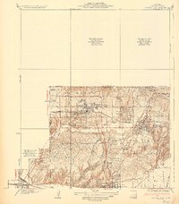
 1904 Southern California Sheet No. 11905 Print · USGSSouthern California at the dawn of the twentieth century shows a landscape of citrus groves and coastal towns connected by rail. Genealogists and historians can trace early settlements like San Juan Capistrano, find remote sites like the Rose Mine, and study the original water systems of the Santa Ana River.2 unique versions available
 - 1927 Map of La Habra
 1927 La Habra1927 Print · USGSSouthern California ranching meets the oil boom in the late twenties as the petroleum industry reshapes the landscape. Genealogists can locate family holdings like Grazide Ranch or trace local education at Lowell Joint School and Rowland School.2 unique versions available
 - 1928 Map of La Brea
 1928 La Brea1928 Print · USGSThe hills of Eastern Los Angeles County are captured here in the late twenties during a period of expanding ranching and early oil exploration. Genealogists and historians can trace family-named sites like Silver Peak Ranch, local landmarks such as Fairview School, and the path of the Union Pacific Railroad.3 unique versions available
 - 1935 Map of Coyote Hills
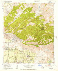
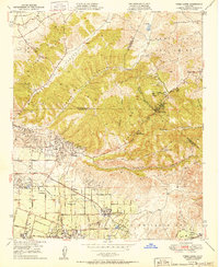
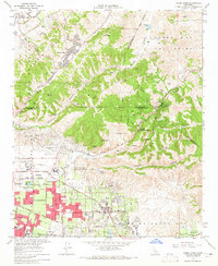
 1935 Coyote Hills1935 Print · USGSThe Orange and Los Angeles county line comes alive in the 1930s as citrus ranches and oil infrastructure began to reshape the Coyote Hills. Researchers can trace the early footprints of Brea, the expansive Bastonchury Ranch, and the Union Oil Tank Farm.2 unique versions available
 - 1935 Map of Olinda
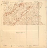
 1935 Olinda1935 Print · USGSOrange County in the mid-1930s shows an evolving landscape of rail lines and irrigation networks. Genealogists and local historians can trace the early footprints of Yorba Linda and Placentia, or locate defunct rail stops like Loftus and Carlton.
 - 1942 Map of Anaheim
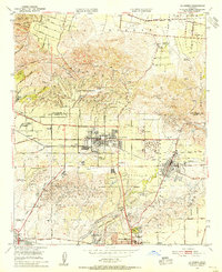
 1942 Anaheim1942 Print · USGSOrange County's agricultural heart is captured mid-century during a period of rapid wartime development. Genealogists can locate family landmarks like Diamond Bar Ranch, local schools such as Alamitos Sch, and communities like Garden Grove or Stanton.2 unique versions available
 - 1947 Map of Santa Ana, 1949 Print
 1947 Santa Ana1949 Print · USGSSouthern California is depicted here in the late forties, showing the expansion of the Inland Empire and the Orange County coast. Researchers can trace the early layout of Palm Springs or locate long-standing tribal lands like the Pala Indian Reservation and Rincon Indian Res.
 - 1949 Map of Santa Ana
 1949 Santa Ana1949 Print · USGSSouthern California underwent a profound transformation in the late 1940s as military installations and citrus groves shared the landscape. Researchers can trace early coastal growth at Laguna Beach, military history at Camp Pendleton, and the rail corridors of the Pacific Electric.
 - 1949 Map of Yorba Linda, 1957 Print
 1949 Yorba Linda1957 Print · USGSOrange and Los Angeles counties meet in this postwar survey during a time of industrial oil production and expanding citrus groves. Researchers can trace early infrastructure like the Pacific Electric railroad and landmarks such as La Vida Mineral Springs or the Olinda Oil Field.2 unique versions available
 - 1950 Map of Yorba Linda
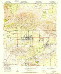
 1950 Yorba Linda1950 Print · USGSMid-century Orange County is caught in a moment of transition between its petroleum roots and growing citrus communities. Genealogists and local historians can trace the early grids of Yorba Linda and Placentia or locate sites like La Vida Mineral Springs and the Olinda Oil Field.
 - 1950 Map of La Habra, 1955 Print
 1950 La Habra1955 Print · USGSNorthern Orange County was a land of sprawling citrus ranches and active oil fields at the midpoint of the century. You can trace the transition from rural estates like Sunny Hills Ranch to the early suburban streets of La Habra and Buena Park.
 - 1952 Map of La Habra
 1952 La Habra1952 Print · USGSThe northern Orange County borderlands and Puente Hills are captured here during a pivotal era of suburban and industrial expansion. Trace the footprints of historic agricultural estates like Leffingwell Ranch or find the early oil derricks and tanks near Brea and La Habra Heights.2 unique versions available
 - 1956 Map of Santa Ana
 1956 Santa Ana1956 Print · USGSSouthern California underwent massive mid-century transformation as suburban growth met major military and water projects. Trace the postwar expansion of Santa Ana and Riverside, the layout of Camp Pendleton, and the path of the Colorado River Aqueduct.
 - 1959 Map of Santa Ana, 1971 Print
 1959 Santa Ana1971 Print · USGSSouthern California is captured in a decade of transformation, from the Orange County coast to the desert floor. Researchers can trace the mid-century footprints of Camp Pendleton, March Air Force Base, and the original Ortega Highway.3 unique versions available
 - 1960 Map of Santa Ana
 1960 Santa Ana1960 Print · USGSSouthern California's coastal plains and inland deserts meet in this mid-century survey of the burgeoning Orange and Riverside county corridors. Researchers can trace the layout of early freeway systems, find tribal lands like the Soboba Indian Reservation, and locate military landmarks such as March Field.2 unique versions available
 - 1964 Map of La Habra, 1965 Print
 1964 La Habra1965 Print · USGSNorth Orange County undergoes a mid-century transformation as suburban neighborhoods rise alongside the active Oil Field landscapes of the La Habra Hills. Researchers can trace the early footprint of Calif State College at Fullerton and locate historic burial grounds like Queen of Heaven Cem.4 unique versions available
 - 1964 Map of Yorba Linda, 1965 Print
 1964 Yorba Linda1965 Print · USGSOrange County's northern hills were transitioning from oil derricks to suburban neighborhoods in the mid-sixties. Local researchers can trace early school sites like Richard M Nixon Sch, explore the grounds of La Vida Mineral Springs, or locate old landmarks in Sleepy Hollow.3 unique versions available
 - 1965 Map of Santa Ana
 1965 Santa Ana1965 Print · USGSSouthern California is captured in a decade of rapid growth, showing the coastal expansion from Santa Ana down to Oceanside. Genealogists and historians can trace the mid-century development of places like Garden Grove or the rural reaches of Escondido and the Palomar Observatory.
 - 1974 Map of La Habra, 1977 Print
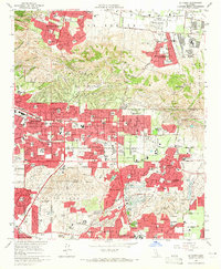
 1974 La Habra1977 Print · USGSOrange County underwent rapid transformation in the mid-seventies, as shown in this detailed aerial study. Genealogists and local historians can trace the specific development of residential blocks and commercial corridors in La Habra and Fullerton.
 - 1981 Map of Yorba Linda, 1982 Print
 1981 Yorba Linda1982 Print · USGSOrange County's northern hills underwent a rapid transition from petroleum production to suburban expansion in the early eighties. Genealogists and local historians can trace specific residential growth around Richard M Nixon Sch and the Brea-Olinda Oil Field.
Showing maps 1-25 of 34
Top cities near Brea
- Long Beach historical maps
- Anaheim historical maps
- Santa Ana historical maps
- Irvine historical maps
- Huntington Beach historical maps
- Ontario historical maps
See more
Top neighborhoods of Brea
Frequently asked questions
- What are the different types of historical maps available for Brea?
- What is the oldest map of Brea?
- Where can I purchase historical maps of Brea for my home or office?
- Where can I download high-res historical maps of Brea?
- Are there historical topographic maps available for Brea?
- Is there historical aerial imagery available for Brea?
- Where are historical maps of Brea sourced from?